La Unión geodata
La Unión (Barinas) is a seat of a third-order administrative division; located in Venezuela in America/Caracas (GMT-4) time zone. In our database, there are 108 cities with bigger population. Compared to other cities in Venezuela, 81.4% of cities are located further ↑North; 60.8% of cities are located further ←West and 77.6% of cities have higher elevation than La Unión. Note1
Administrative division(s):
- Level 1: Barinas
- Level 2: Municipio Arismendi
- Level 3: Parroquia La Unión


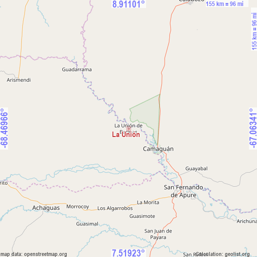
La Unión GPS coordinates[2]
8° 12' 56.628" North, 67° 45' 59.508" West
| Map corner | latitude | longitude |
|---|---|---|
| Upper-left | 8.91101°, | -68.46966° |
| Center: | 8.21573°, | -67.76653° |
| Lower-right: | 7.51923°, | -67.06341° |
| Map W x H: | 154.8×154.8 km | = 96.2×96.2mi |
| max Lat: | 11.94788° ⇑81.4% North |
| La Unión: | 8.21573° |
| min Lat: | ⇓18.6% South 1.92027° |
| min Long | La Unión | max Long |
| -72.55212° | -67.76653° | -60.99778° |
| W 60.8%⇐ | ⇒39.2% E |
Elevation
Elevation of La Unión is 59 m = 194 ft, and this is 321.6 m = 1055 ft below average elevation for this country.
| Max E: |
2986 m = 9797 ft | 77.6% |
| Avg. | 380.6 m = 1249 ft | |
| La Unión | 59 m = 194 ft | |
Min E: |
-4 m = -13 ft | 22.4% |
See also: Venezuela elevation on elevation.city.
Geographical zone
La Unión is located in North Torrid zone (between Equator and Tropic of Cancer). Distance of Equator is 913.5 km =567.6 mi to South.| Distance of | km | miles | from La Unión |
|---|---|---|---|
| North Pole | 9093.6 | 5650.5 | to North |
| Arctic Circle | 6487.7 | 4031.3 | to North |
| Tropic Cancer | 1692.4 | 1051.6 | to North |
| Equator | 913.5 | 567.6 | to South |


Nearby cities:
15 places around La Unión: (largest is in red/bold)
• Achaguas
69.9 km =43.4 mi,  226°
226°
• Arismendi
72.6 km =45.1 mi,  293°
293°
• Biruaca
49.6 km =30.8 mi,  146°
146°
• Calabozo
87.1 km =54.1 mi,  25°
25°
• Camaguán
21.3 km =13.2 mi,  124°
124°
• El Baúl
101.3 km =62.9 mi,  325°
325°
• El Regalo
157 km =97.6 mi,  278°
278°
• El Sombrero
151.7 km =94.3 mi, 30°
• Guadarrama
47.2 km =29.3 mi,  318°
318°
• Guayabal
47.1 km =29.3 mi, 120°
• Palmasola
161.6 km =100.4 mi,  45°
45°
• San Antonio
78.6 km =48.8 mi,  249°
249°
• San Fernando de Apure
48.8 km =30.3 mi,  138°
138°
• San Juan de Payara
65.7 km =40.8 mi,  164°
164°
• Santa Catalina
130.8 km =81.3 mi,  255°
255°
Sources, notices
• [Note1] Compared only with cities in Venezuela existing in our database
• [Src1] Map data: © OpenStreetMap contributors (CC-BY-SA)
• [Src2] Other city data from geonames.org with taken over terms of usage.
• [Src3] Geographical zone / Annual Mean Temperature by Robert A. Rohde @ Wikipedia
