Guadarrama geodata
Guadarrama (Barinas) is a seat of a third-order administrative division; located in Venezuela in America/Caracas (GMT-4) time zone. In our database, there are 108 cities with bigger population. Compared to other cities in Venezuela, 74% of cities are located further ↑North; 57.8% of cities are located further ←West and 75.6% of cities have higher elevation than Guadarrama. Note1
Administrative division(s):
- Level 1: Barinas
- Level 2: Municipio Arismendi
- Level 3: Parroquia Guadarrama


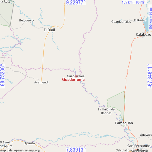
Guadarrama GPS coordinates[2]
8° 32' 6.288" North, 68° 2' 57.228" West
| Map corner | latitude | longitude |
|---|---|---|
| Upper-left | 9.22977°, | -68.75236° |
| Center: | 8.53508°, | -68.04923° |
| Lower-right: | 7.83913°, | -67.34611° |
| Map W x H: | 154.6×154.6 km | = 96.1×96.1mi |
| max Lat: | 11.94788° ⇑74% North |
| Guadarrama: | 8.53508° |
| min Lat: | ⇓26% South 1.92027° |
| min Long | Guadarrama | max Long |
| -72.55212° | -68.04923° | -60.99778° |
| W 57.8%⇐ | ⇒42.2% E |
Elevation
Elevation of Guadarrama is 63 m = 207 ft, and this is 317.6 m = 1042 ft below average elevation for this country.
| Max E: |
2986 m = 9797 ft | 75.6% |
| Avg. | 380.6 m = 1249 ft | |
| Guadarrama | 63 m = 207 ft | |
Min E: |
-4 m = -13 ft | 24.4% |
See also: Venezuela elevation on elevation.city.
Geographical zone
Guadarrama is located in North Torrid zone (between Equator and Tropic of Cancer). Distance of Equator is 949 km =589.7 mi to South.| Distance of | km | miles | from Guadarrama |
|---|---|---|---|
| North Pole | 9058 | 5628.4 | to North |
| Arctic Circle | 6452.2 | 4009.2 | to North |
| Tropic Cancer | 1656.9 | 1029.5 | to North |
| Equator | 949 | 589.7 | to South |


Nearby cities:
15 places around Guadarrama: (largest is in red/bold)
• Achaguas
86.2 km =53.6 mi,  192°
192°
• Arismendi
35.8 km =22.2 mi,  260°
260°
• Biruaca
96.6 km =60 mi,  142°
142°
• Calabozo
80.7 km =50.1 mi,  57°
57°
• Camaguán
68 km =42.3 mi,  134°
134°
• El Baúl
54.6 km =33.9 mi,  330°
330°
• El Pao
123.1 km =76.5 mi,  355°
355°
• El Regalo
124.5 km =77.4 mi, 264°
• Guayabal
93.1 km =57.8 mi, 129°
• La Unión
47.2 km =29.3 mi, 138°
• Libertad
115.5 km =71.8 mi,  322°
322°
• San Antonio
76.3 km =47.4 mi,  213°
213°
• San Fernando de Apure
96 km =59.7 mi, 138°
• San Juan de Payara
110.1 km =68.4 mi,  153°
153°
• Santa Catalina
117.2 km =72.8 mi,  234°
234°
Sources, notices
• [Note1] Compared only with cities in Venezuela existing in our database
• [Src1] Map data: © OpenStreetMap contributors (CC-BY-SA)
• [Src2] Other city data from geonames.org with taken over terms of usage.
• [Src3] Geographical zone / Annual Mean Temperature by Robert A. Rohde @ Wikipedia
