Bình Long geodata
Bình Long (Bình Phước) is a populated place; located in Vietnam in Asia/Ho_Chi_Minh (GMT+7) time zone. With population of 15,000 people, there are 86 cities with bigger population in this country. Compared to other cities in Vietnam, 69.3% of cities are located further ↑North; 65.7% of cities are located further ←West and 77% of cities have lower elevation than Bình Long. Note1


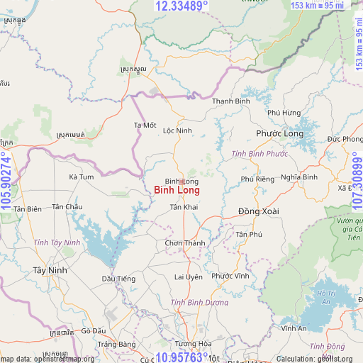
Bình Long GPS coordinates[2]
11° 38' 49.596" North, 106° 36' 21.096" East
| Map corner | latitude | longitude |
|---|---|---|
| Upper-left | 12.33489°, | 105.90274° |
| Center: | 11.64711°, | 106.60586° |
| Lower-right: | 10.95763°, | 107.30899° |
| Map W x H: | 153.1×153.1 km | = 95.1×95.1mi |
| max Lat: | 23.27841° ⇑69.3% North |
| Bình Long: | 11.64711° |
| min Lat: | ⇓30.7% South 8.65724° |
| min Long | Bình Long | max Long |
| 102.4579° | 106.60586° | 112.72541° |
| W 65.7%⇐ | ⇒34.3% E |
Elevation
Elevation of Bình Long is 126 m = 413 ft, and this is 3.5 m = 11 ft below average elevation for this country.
| Max E: |
1592 m = 5223 ft | 23% |
| Avg. | 129.5 m = 425 ft | |
| Bình Long | 126 m = 413 ft | |
Min E: |
-1 m = -3 ft | 77% |
See also: Vietnam elevation on elevation.city.
Geographical zone
Bình Long is located in North Torrid zone (between Equator and Tropic of Cancer). Distance of Equator is 1295 km =804.7 mi to South.| Distance of | km | miles | from Bình Long |
|---|---|---|---|
| North Pole | 8712 | 5413.4 | to North |
| Arctic Circle | 6106.1 | 3794.2 | to North |
| Tropic Cancer | 1310.9 | 814.6 | to North |
| Equator | 1295 | 804.7 | to South |


Nearby cities:
15 places around Bình Long: (largest is in red/bold)
• Bù Đốp
40.2 km =25 mi,  31°
31°
• Chơn Thành
24.6 km =15.3 mi,  172°
172°
• Don Luan
32.7 km =20.3 mi,  112°
112°
• Dương Minh Châu
50.2 km =31.2 mi,  234°
234°
• Dầu Tiếng
49.4 km =30.7 mi,  212°
212°
• Gò Dầu
72.5 km =45 mi, 211°
• Hòa Thành
65.6 km =40.8 mi, 232°
• Lộc Ninh
22 km =13.7 mi,  355°
355°
• Phú Khương
65.5 km =40.7 mi, 231°
• Tân Biên
65.7 km =40.8 mi,  259°
259°
• Tân Châu
48.4 km =30.1 mi, 257°
• Tân Phú
35.9 km =22.3 mi,  127°
127°
• Tây Ninh
66.8 km =41.5 mi,  235°
235°
• Uyen Hung
65.7 km =40.8 mi,  162°
162°
• Đức Phong
71.9 km =44.7 mi,  75°
75°
Sources, notices
• [Note1] Compared only with cities in Vietnam existing in our database
• [Src1] Map data: © OpenStreetMap contributors (CC-BY-SA)
• [Src2] Other city data from geonames.org with taken over terms of usage.
• [Src3] Geographical zone / Annual Mean Temperature by Robert A. Rohde @ Wikipedia
