Thái Nguyên geodata
Thái Nguyên is a seat of a first-order administrative division; located in Vietnam in Asia/Ho_Chi_Minh (GMT+7) time zone. With population of 133,877 people, there are 26 cities with bigger population in this country. Compared to other cities in Vietnam, 87.3% of cities are located further ↓South; 61.5% of cities are located further →East and 65.7% of cities have lower elevation than Thái Nguyên. Note1


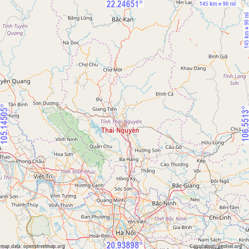
Thái Nguyên GPS coordinates[2]
21° 35' 39.192" North, 105° 50' 53.412" East
| Map corner | latitude | longitude |
|---|---|---|
| Upper-left | 22.24651°, | 105.14505° |
| Center: | 21.59422°, | 105.84817° |
| Lower-right: | 20.93898°, | 106.5513° |
| Map W x H: | 145.4×145.4 km | = 90.3×90.3mi |
| max Lat: | 23.27841° ⇑12.7% North |
| Thái Nguyên: | 21.59422° |
| min Lat: | ⇓87.3% South 8.65724° |
| min Long | Thái Nguyên | max Long |
| 102.4579° | 105.84817° | 112.72541° |
| W 38.5%⇐ | ⇒61.5% E |
Elevation
Elevation of Thái Nguyên is 36 m = 118 ft, and this is 93.5 m = 307 ft below average elevation for this country.
| Max E: |
1592 m = 5223 ft | 34.3% |
| Avg. | 129.5 m = 425 ft | |
| Thái Nguyên | 36 m = 118 ft | |
Min E: |
-1 m = -3 ft | 65.7% |
See also: Thái Nguyên elevation on elevation.city.
Geographical zone
Thái Nguyên is located in North Torrid zone (between Equator and Tropic of Cancer). Distance of this Northern Tropic circle is 204.9 km =127.3 mi to North.| Distance of | km | miles | from Thái Nguyên |
|---|---|---|---|
| North Pole | 7606 | 4726.1 | to North |
| Arctic Circle | 5000.1 | 3106.9 | to North |
| Tropic Cancer | 204.9 | 127.3 | to North |
| Equator | 2401.1 | 1492 | to South |


Nearby cities:
15 places around Thái Nguyên: (largest is in red/bold)
• Bích Động
44.1 km =27.4 mi,  143°
143°
• Cao Thượng
37.1 km =23.1 mi,  128°
128°
• Chùa Hang
3.4 km =2.1 mi,  348°
348°
• Chợ Chu
40.8 km =25.4 mi,  328°
328°
• Chợ Mới
33.1 km =20.6 mi, 346°
• Cầu Gồ
31.6 km =19.6 mi,  114°
114°
• Hương Canh
40.8 km =25.4 mi,  210°
210°
• Hương Sơn
20.1 km =12.5 mi, 137°
• Hợp Hòa
39.9 km =24.8 mi,  232°
232°
• Phúc Yên
42.4 km =26.3 mi,  200°
200°
• Sóc Sơn
37.4 km =23.2 mi,  179°
179°
• Thắng
30.1 km =18.7 mi,  152°
152°
• Trai Ngau
32.9 km =20.4 mi, 227°
• Vĩnh Yên
40.5 km =25.2 mi,  218°
218°
• Đu
21.9 km =13.6 mi,  317°
317°
Sources, notices
• [Note1] Compared only with cities in Vietnam existing in our database
• [Src1] Map data: © OpenStreetMap contributors (CC-BY-SA)
• [Src2] Other city data from geonames.org with taken over terms of usage.
• [Src3] Geographical zone / Annual Mean Temperature by Robert A. Rohde @ Wikipedia
