Ghayl Bā Wazīr geodata
Ghayl Bā Wazīr (Ḩaḑramawt) is a seat of a second-order administrative division; located in Yemen in Asia/Aden (GMT+3) time zone. In our database, there are 51 cities with bigger population. Compared to other cities in Yemen, 52.6% of cities are located further ↑North; 94.5% of cities are located further ←West and 88% of cities have higher elevation than Ghayl Bā Wazīr. Note1


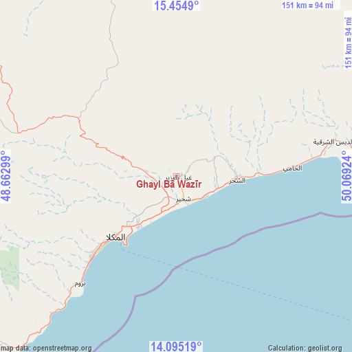
Ghayl Bā Wazīr GPS coordinates[2]
14° 46' 33.996" North, 49° 21' 57.996" East
| Map corner | latitude | longitude |
|---|---|---|
| Upper-left | 15.4549°, | 48.66299° |
| Center: | 14.77611°, | 49.36611° |
| Lower-right: | 14.09519°, | 50.06924° |
| Map W x H: | 151.2×151.2 km | = 94×94mi |
| max Lat: | 17.76999° ⇑52.6% North |
| Ghayl Bā Wazīr: | 14.77611° |
| min Lat: | ⇓47.4% South 12.18576° |
| min Long | Ghayl Bā Wazī | max Long |
| 42.67107° | 49.36611° | 54.01895° |
| W 94.5%⇐ | ⇒5.5% E |
Elevation
Elevation of Ghayl Bā Wazīr is 87 m = 285 ft, and this is 1217.8 m = 3995 ft below average elevation for this country.
| Max E: |
2791 m = 9157 ft | 88% |
| Avg. | 1304.8 m = 4281 ft | |
| Ghayl Bā Wazīr | 87 m = 285 ft | |
Min E: |
4 m = 13 ft | 12% |
See also: Yemen elevation on elevation.city.
Geographical zone
Ghayl Bā Wazīr is located in North Torrid zone (between Equator and Tropic of Cancer). Distance of this Northern Tropic circle is 963 km =598.4 mi to North.| Distance of | km | miles | from Ghayl Bā Wazīr |
|---|---|---|---|
| North Pole | 8364.1 | 5197.2 | to North |
| Arctic Circle | 5758.2 | 3578 | to North |
| Tropic Cancer | 963 | 598.4 | to North |
| Equator | 1642.9 | 1020.9 | to South |


Nearby cities:
15 places around Ghayl Bā Wazīr: (largest is in red/bold)
• Ad Dīs ash Sharqīyah
64.3 km =40 mi,  76°
76°
• Al Bāţinah
127.3 km =79.1 mi,  308°
308°
• Al Jawl
122.1 km =75.9 mi,  253°
253°
• Al Ḩamdī
144.6 km =89.9 mi,  334°
334°
• Al ‘Ulayb
51.9 km =32.2 mi,  322°
322°
• Al ‘Ummāl
143.5 km =89.2 mi,  335°
335°
• Ar Raydah
123 km =76.4 mi, 76°
• Ash Shiḩr
25.8 km =16 mi,  93°
93°
• At Taḩāluf
143.3 km =89 mi, 334°
• Ath Thawrah
143.8 km =89.4 mi, 334°
• Burūm
61.9 km =38.5 mi,  222°
222°
• Bāḩashawān
143.9 km =89.4 mi, 334°
• Mukalla
36.8 km =22.9 mi,  225°
225°
• Sāh
104.9 km =65.2 mi, 328°
• Şīf
126.3 km =78.5 mi,  298°
298°
Sources, notices
• [Note1] Compared only with cities in Yemen existing in our database
• [Src1] Map data: © OpenStreetMap contributors (CC-BY-SA)
• [Src2] Other city data from geonames.org with taken over terms of usage.
• [Src3] Geographical zone / Annual Mean Temperature by Robert A. Rohde @ Wikipedia
