Burūm geodata
Burūm (Ḩaḑramawt) is a seat of a second-order administrative division; located in Yemen in Asia/Aden (GMT+3) time zone. In our database, there are 51 cities with bigger population. Compared to other cities in Yemen, 63.3% of cities are located further ↑North; 92.9% of cities are located further ←West and 90.6% of cities have higher elevation than Burūm. Note1


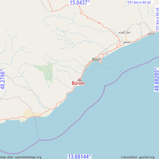
Burūm GPS coordinates[2]
14° 21' 48.996" North, 48° 58' 46.992" East
| Map corner | latitude | longitude |
|---|---|---|
| Upper-left | 15.0437°, | 48.2766° |
| Center: | 14.36361°, | 48.97972° |
| Lower-right: | 13.68144°, | 49.68285° |
| Map W x H: | 151.5×151.5 km | = 94.1×94.1mi |
| max Lat: | 17.76999° ⇑63.3% North |
| Burūm: | 14.36361° |
| min Lat: | ⇓36.7% South 12.18576° |
| min Long | Burūm | max Long |
| 42.67107° | 48.97972° | 54.01895° |
| W 92.9%⇐ | ⇒7.1% E |
Elevation
Elevation of Burūm is 44 m = 144 ft, and this is 1260.8 m = 4136 ft below average elevation for this country.
| Max E: |
2791 m = 9157 ft | 90.6% |
| Avg. | 1304.8 m = 4281 ft | |
| Burūm | 44 m = 144 ft | |
Min E: |
4 m = 13 ft | 9.4% |
See also: Yemen elevation on elevation.city.
Geographical zone
Burūm is located in North Torrid zone (between Equator and Tropic of Cancer). Distance of this Northern Tropic circle is 1008.8 km =626.8 mi to North.| Distance of | km | miles | from Burūm |
|---|---|---|---|
| North Pole | 8410 | 5225.7 | to North |
| Arctic Circle | 5804.1 | 3606.5 | to North |
| Tropic Cancer | 1008.8 | 626.8 | to North |
| Equator | 1597.1 | 992.4 | to South |


Nearby cities:
15 places around Burūm: (largest is in red/bold)
• Ad Dīs ash Sharqīyah
120.5 km =74.9 mi,  59°
59°
• Al Bāţinah
137.6 km =85.5 mi,  334°
334°
• Al Jawl
76 km =47.2 mi,  277°
277°
• Al Shirūj
135.1 km =83.9 mi,  285°
285°
• Al ‘Ulayb
87.7 km =54.5 mi,  6°
6°
• Ash Shiḩr
80.5 km =50 mi, 56°
• Az̧ Z̧alī‘ah
126.5 km =78.6 mi,  305°
305°
• Ghayl Bā Wazīr
61.9 km =38.5 mi,  42°
42°
• Mayfa‘ah
150.7 km =93.6 mi,  266°
266°
• Mukalla
25.3 km =15.7 mi, 38°
• Ruḑūm
136.8 km =85 mi,  256°
256°
• Sāh
135.7 km =84.3 mi,  354°
354°
• Şīf
126.7 km =78.7 mi, 326°
• Ḩurayḑah
161.8 km =100.5 mi, 328°
• ‘Amd
149.4 km =92.8 mi, 314°
Sources, notices
• [Note1] Compared only with cities in Yemen existing in our database
• [Src1] Map data: © OpenStreetMap contributors (CC-BY-SA)
• [Src2] Other city data from geonames.org with taken over terms of usage.
• [Src3] Geographical zone / Annual Mean Temperature by Robert A. Rohde @ Wikipedia
