Lephalale geodata
Lephalale (Limpopo) is a seat of a third-order administrative division; located in South Africa in Africa/Johannesburg (GMT+2) time zone. In our database, there are 257 cities with bigger population. Compared to other cities in South Africa, 97.6% of cities are located further ↓South; 50.4% of cities are located further ←West and 65.2% of cities have higher elevation than Lephalale. Note1
Administrative division(s):
- Level 1: Limpopo
- Level 2: Waterberg District Municipality
- Level 3: Lephalale


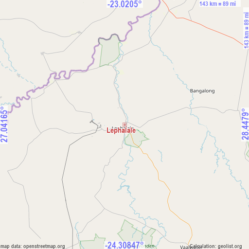
Lephalale GPS coordinates[2]
23° 39' 57.852" South, 27° 44' 41.172" East
| Map corner | latitude | longitude |
|---|---|---|
| Upper-left | -23.0205°, | 27.04165° |
| Center: | -23.66607°, | 27.74477° |
| Lower-right: | -24.30847°, | 28.4479° |
| Map W x H: | 143.2×143.2 km | = 89×89mi |
| max Lat: | -22.34881° ⇑2.4% North |
| Lephalale: | -23.66607° |
| min Lat: | ⇓97.6% South -34.66739° |
| min Long | Lephalale | max Long |
| 16.8697° | 27.74477° | 32.26762° |
| W 50.4%⇐ | ⇒49.6% E |
Elevation
Elevation of Lephalale is 824 m = 2703 ft, and this is 145.6 m = 478 ft below average elevation for this country.
| Max E: |
1873 m = 6145 ft | 65.2% |
| Avg. | 969.6 m = 3181 ft | |
| Lephalale | 824 m = 2703 ft | |
Min E: |
7 m = 23 ft | 34.8% |
See also: South Africa elevation on elevation.city.
Geographical zone
Lephalale is located in South temperate zone (between Tropic of Capricorn and the Antarctic Circle). Distance of this Southern Tropic circle is 25.5 km =15.8 mi to North.| Distance of | km | miles | from Lephalale |
|---|---|---|---|
| Equator | 2631.4 | 1635.1 | to North |
| Tropic Capricorn | 25.5 | 15.8 | to North |
| Antarctic Circle | 4769.8 | 2963.8 | to South |
| South Pole | 7375.6 | 4583 | to South |


Nearby cities:
15 places around Lephalale: (largest is in red/bold)
• Bela-Bela
146.5 km =91 mi,  157°
157°
• Bochum
148.4 km =92.2 mi,  73°
73°
• Dendron
164.4 km =102.2 mi,  78°
78°
• Lebowakgomo
188 km =116.8 mi,  108°
108°
• Mabopane
206.8 km =128.5 mi,  169°
169°
• Maile
202.9 km =126.1 mi,  193°
193°
• Makapanstad
179.6 km =111.6 mi, 167°
• Mankoeng
212.4 km =132 mi,  97°
97°
• Modimolle
132.8 km =82.5 mi,  149°
149°
• Mogwase
187 km =116.2 mi,  196°
196°
• Mokopane
141.3 km =87.8 mi, 114°
• Polokwane
177.4 km =110.2 mi, 98°
• Siyabuswa
207.9 km =129.2 mi,  140°
140°
• Thabazimbi
108.3 km =67.3 mi, 198°
• Warmbaths
145.9 km =90.7 mi, 158°
Sources, notices
• [Note1] Compared only with cities in South Africa existing in our database
• [Src1] Map data: © OpenStreetMap contributors (CC-BY-SA)
• [Src2] Other city data from geonames.org with taken over terms of usage.
• [Src3] Geographical zone / Annual Mean Temperature by Robert A. Rohde @ Wikipedia
