Modimolle geodata
Modimolle (Limpopo) is a seat of a second-order administrative division; located in South Africa in Africa/Johannesburg (GMT+2) time zone. With population of 20,527 people, there are 143 cities with bigger population in this country. Compared to other cities in South Africa, 93.8% of cities are located further ↓South; 64% of cities are located further ←West and 54.3% of cities have lower elevation than Modimolle. Note1
Administrative division(s):
- Level 1: Limpopo
- Level 2: Waterberg District Municipality
- Level 3: Modimolle


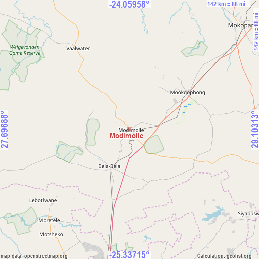
Modimolle GPS coordinates[2]
24° 42' 0" South, 28° 24' 0" East
| Map corner | latitude | longitude |
|---|---|---|
| Upper-left | -24.05958°, | 27.69688° |
| Center: | -24.7°, | 28.4° |
| Lower-right: | -25.33715°, | 29.10313° |
| Map W x H: | 142.1×142.1 km | = 88.3×88.3mi |
| max Lat: | -22.34881° ⇑6.2% North |
| Modimolle: | -24.7° |
| min Lat: | ⇓93.8% South -34.66739° |
| min Long | Modimolle | max Long |
| 16.8697° | 28.4° | 32.26762° |
| W 64%⇐ | ⇒36% E |
Elevation
Elevation of Modimolle is 1177 m = 3862 ft, and this is 207.4 m = 680 ft above average elevation for this country.
| Max E: |
1873 m = 6145 ft | 45.7% |
| Modimolle | 1177 m 3862 ft | |
| Avg. | 969.6 m = 3181 ft | |
Min E: |
7 m = 23 ft | 54.3% |
See also: South Africa elevation on elevation.city.
Geographical zone
Modimolle is located in South temperate zone (between Tropic of Capricorn and the Antarctic Circle). Distance of this Southern Tropic circle is 140.5 km =87.3 mi to North.| Distance of | km | miles | from Modimolle |
|---|---|---|---|
| Equator | 2746.4 | 1706.5 | to North |
| Tropic Capricorn | 140.5 | 87.3 | to North |
| Antarctic Circle | 4654.8 | 2892.4 | to South |
| South Pole | 7260.7 | 4511.6 | to South |


Nearby cities:
15 places around Modimolle: (largest is in red/bold)
• Bela-Bela
23.2 km =14.4 mi,  207°
207°
• Brits
121.2 km =75.3 mi, 210°
• Cullinan
108.7 km =67.5 mi,  173°
173°
• Ekangala
116.2 km =72.2 mi,  162°
162°
• Ga-Rankuwa
109.8 km =68.2 mi,  201°
201°
• Groblersdal
113 km =70.2 mi,  117°
117°
• Lebowakgomo
124.4 km =77.3 mi,  63°
63°
• Mabopane
93.7 km =58.2 mi, 198°
• Makapanstad
66.5 km =41.3 mi, 204°
• Marble Hall
94.6 km =58.8 mi,  108°
108°
• Mokopane
83.5 km =51.9 mi,  47°
47°
• Pretoria
118.1 km =73.4 mi,  190°
190°
• Siyabuswa
79.6 km =49.5 mi,  125°
125°
• Thabazimbi
100.6 km =62.5 mi,  276°
276°
• Warmbaths
23.5 km =14.6 mi, 210°
Sources, notices
• [Note1] Compared only with cities in South Africa existing in our database
• [Src1] Map data: © OpenStreetMap contributors (CC-BY-SA)
• [Src2] Other city data from geonames.org with taken over terms of usage.
• [Src3] Geographical zone / Annual Mean Temperature by Robert A. Rohde @ Wikipedia
