Bela-Bela geodata
Bela-Bela (Limpopo) is a seat of a third-order administrative division; located in South Africa in Africa/Johannesburg (GMT+2) time zone. In our database, there are 257 cities with bigger population. Compared to other cities in South Africa, 92.6% of cities are located further ↓South; 62.2% of cities are located further ←West and 51.6% of cities have lower elevation than Bela-Bela. Note1
Administrative division(s):
- Level 1: Limpopo
- Level 2: Waterberg District Municipality
- Level 3: Bela-Bela


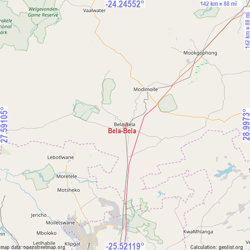
Bela-Bela GPS coordinates[2]
24° 53' 6" South, 28° 17' 39.012" East
| Map corner | latitude | longitude |
|---|---|---|
| Upper-left | -24.24552°, | 27.59105° |
| Center: | -24.885°, | 28.29417° |
| Lower-right: | -25.52119°, | 28.9973° |
| Map W x H: | 141.8×141.8 km | = 88.1×88.1mi |
| max Lat: | -22.34881° ⇑7.4% North |
| Bela-Bela: | -24.885° |
| min Lat: | ⇓92.6% South -34.66739° |
| min Long | Bela-Bela | max Long |
| 16.8697° | 28.29417° | 32.26762° |
| W 62.2%⇐ | ⇒37.8% E |
Elevation
Elevation of Bela-Bela is 1130 m = 3707 ft, and this is 160.4 m = 526 ft above average elevation for this country.
| Max E: |
1873 m = 6145 ft | 48.4% |
| Bela-Bela | 1130 m 3707 ft | |
| Avg. | 969.6 m = 3181 ft | |
Min E: |
7 m = 23 ft | 51.6% |
See also: South Africa elevation on elevation.city.
Geographical zone
Bela-Bela is located in South temperate zone (between Tropic of Capricorn and the Antarctic Circle). Distance of this Southern Tropic circle is 161 km =100 mi to North.| Distance of | km | miles | from Bela-Bela |
|---|---|---|---|
| Equator | 2767 | 1719.3 | to North |
| Tropic Capricorn | 161 | 100 | to North |
| Antarctic Circle | 4634.2 | 2879.6 | to South |
| South Pole | 7240.1 | 4498.8 | to South |


Nearby cities:
15 places around Bela-Bela: (largest is in red/bold)
• Brits
98.1 km =61 mi,  211°
211°
• Bronkhorstspruit
112.3 km =69.8 mi,  156°
156°
• Centurion
108.8 km =67.6 mi,  185°
185°
• Cullinan
90.4 km =56.2 mi,  165°
165°
• Ekangala
101.1 km =62.8 mi,  153°
153°
• Ga-Rankuwa
86.8 km =53.9 mi,  200°
200°
• Mabopane
70.9 km =44.1 mi, 195°
• Makapanstad
43.3 km =26.9 mi, 202°
• Marble Hall
100.9 km =62.7 mi,  95°
95°
• Modimolle
23.2 km =14.4 mi,  27°
27°
• Mokopane
105.5 km =65.6 mi,  43°
43°
• Pretoria
96.2 km =59.8 mi, 186°
• Siyabuswa
79.8 km =49.6 mi,  108°
108°
• Thabazimbi
94.9 km =59 mi,  290°
290°
• Warmbaths
1.1 km =0.7 mi,  279°
279°
Sources, notices
• [Note1] Compared only with cities in South Africa existing in our database
• [Src1] Map data: © OpenStreetMap contributors (CC-BY-SA)
• [Src2] Other city data from geonames.org with taken over terms of usage.
• [Src3] Geographical zone / Annual Mean Temperature by Robert A. Rohde @ Wikipedia
