Polokwane geodata
Polokwane (Limpopo) is a seat of a first-order administrative division; located in South Africa in Africa/Johannesburg (GMT+2) time zone. With population of 123,749 people, there are 43 cities with bigger population in this country. Compared to other cities in South Africa, 96.2% of cities are located further ↓South; 74.3% of cities are located further ←West and 64.9% of cities have lower elevation than Polokwane. Note1
Administrative division(s):
- Level 1: Limpopo
- Level 2: Capricorn District Municipality
- Level 3: Polokwane


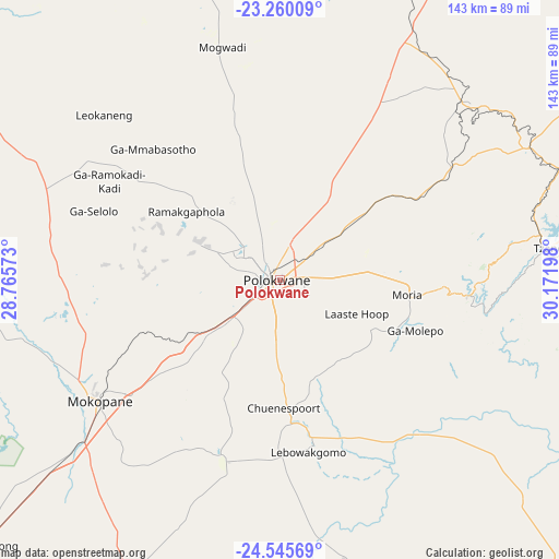
Polokwane GPS coordinates[2]
23° 54' 16.164" South, 29° 28' 7.86" East
| Map corner | latitude | longitude |
|---|---|---|
| Upper-left | -23.26009°, | 28.76573° |
| Center: | -23.90449°, | 29.46885° |
| Lower-right: | -24.54569°, | 30.17198° |
| Map W x H: | 142.9×142.9 km | = 88.8×88.8mi |
| max Lat: | -22.34881° ⇑3.8% North |
| Polokwane: | -23.90449° |
| min Lat: | ⇓96.2% South -34.66739° |
| min Long | Polokwane | max Long |
| 16.8697° | 29.46885° | 32.26762° |
| W 74.3%⇐ | ⇒25.7% E |
Elevation
Elevation of Polokwane is 1315 m = 4314 ft, and this is 345.4 m = 1133 ft above average elevation for this country.
| Max E: |
1873 m = 6145 ft | 35.1% |
| Polokwane | 1315 m 4314 ft | |
| Avg. | 969.6 m = 3181 ft | |
Min E: |
7 m = 23 ft | 64.9% |
See also: Polokwane elevation on elevation.city.
Geographical zone
Polokwane is located in South temperate zone (between Tropic of Capricorn and the Antarctic Circle). Distance of this Southern Tropic circle is 52 km =32.3 mi to North.| Distance of | km | miles | from Polokwane |
|---|---|---|---|
| Equator | 2657.9 | 1651.5 | to North |
| Tropic Capricorn | 52 | 32.3 | to North |
| Antarctic Circle | 4743.2 | 2947.3 | to South |
| South Pole | 7349.1 | 4566.5 | to South |


Nearby cities:
15 places around Polokwane: (largest is in red/bold)
• Apel
63.5 km =39.5 mi,  153°
153°
• Bochum
76.5 km =47.5 mi,  333°
333°
• Burgersfort
122.2 km =75.9 mi,  134°
134°
• Dendron
61.6 km =38.3 mi,  346°
346°
• Duiwelskloof
72.2 km =44.9 mi,  71°
71°
• Ga-Kgapane
82.1 km =51 mi, 69°
• Jane Furse
103.5 km =64.3 mi,  156°
156°
• Lebowakgomo
33 km =20.5 mi,  174°
174°
• Louis Trichardt
105.4 km =65.5 mi,  24°
24°
• Mankoeng
35.4 km =22 mi,  89°
89°
• Marble Hall
119.4 km =74.2 mi,  188°
188°
• Modimolle
139.8 km =86.9 mi,  230°
230°
• Mokopane
56.7 km =35.2 mi,  235°
235°
• Nkowakowa
83.2 km =51.7 mi, 88°
• Tzaneen
71.1 km =44.2 mi,  83°
83°
Sources, notices
• [Note1] Compared only with cities in South Africa existing in our database
• [Src1] Map data: © OpenStreetMap contributors (CC-BY-SA)
• [Src2] Other city data from geonames.org with taken over terms of usage.
• [Src3] Geographical zone / Annual Mean Temperature by Robert A. Rohde @ Wikipedia
