Standerton geodata
Standerton (Mpumalanga) is a seat of a third-order administrative division; located in South Africa in Africa/Johannesburg (GMT+2) time zone. With population of 74,021 people, there are 69 cities with bigger population in this country. Compared to other cities in South Africa, 69% of cities are located further ↓South; 71.7% of cities are located further ←West and 86.4% of cities have lower elevation than Standerton. Note1
Administrative division(s):
- Level 1: Mpumalanga
- Level 2: Gert Sibande District Municipality
- Level 3: Lekwa


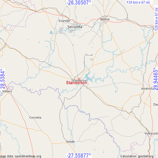
Standerton GPS coordinates[2]
26° 56' 1.176" South, 29° 14' 29.472" East
| Map corner | latitude | longitude |
|---|---|---|
| Upper-left | -26.30507°, | 28.5384° |
| Center: | -26.93366°, | 29.24152° |
| Lower-right: | -27.55877°, | 29.94465° |
| Map W x H: | 139.4×139.4 km | = 86.6×86.6mi |
| max Lat: | -22.34881° ⇑31% North |
| Standerton: | -26.93366° |
| min Lat: | ⇓69% South -34.66739° |
| min Long | Standerton | max Long |
| 16.8697° | 29.24152° | 32.26762° |
| W 71.7%⇐ | ⇒28.3% E |
Elevation
Elevation of Standerton is 1569 m = 5148 ft, and this is 599.4 m = 1967 ft above average elevation for this country.
| Max E: |
1873 m = 6145 ft | 13.6% |
| Standerton | 1569 m 5148 ft | |
| Avg. | 969.6 m = 3181 ft | |
Min E: |
7 m = 23 ft | 86.4% |
See also: Standerton elevation on elevation.city.
Geographical zone
Standerton is located in South temperate zone (between Tropic of Capricorn and the Antarctic Circle). Distance of this Southern Tropic circle is 388.8 km =241.6 mi to North.| Distance of | km | miles | from Standerton |
|---|---|---|---|
| Equator | 2994.7 | 1860.8 | to North |
| Tropic Capricorn | 388.8 | 241.6 | to North |
| Antarctic Circle | 4406.4 | 2738 | to South |
| South Pole | 7012.3 | 4357.2 | to South |


Nearby cities:
15 places around Standerton: (largest is in red/bold)
• Balfour
71.3 km =44.3 mi,  294°
294°
• Bethal
57.4 km =35.7 mi,  22°
22°
• Breyten
102.1 km =63.4 mi,  46°
46°
• Delmas
103.6 km =64.4 mi,  327°
327°
• Ermelo
86.1 km =53.5 mi,  58°
58°
• Frankfort
83.1 km =51.6 mi,  242°
242°
• Heidelberg
99.8 km =62 mi,  298°
298°
• Hendrina
98.2 km =61 mi,  28°
28°
• Kriel
73.4 km =45.6 mi,  358°
358°
• Nigel
94.3 km =58.6 mi,  306°
306°
• Secunda
43.3 km =26.9 mi,  350°
350°
• Villiers
64.4 km =40 mi,  260°
260°
• Volksrust
79.5 km =49.4 mi,  127°
127°
• Vrede
55.2 km =34.3 mi,  187°
187°
• eMbalenhle
47.8 km =29.7 mi,  338°
338°
Sources, notices
• [Note1] Compared only with cities in South Africa existing in our database
• [Src1] Map data: © OpenStreetMap contributors (CC-BY-SA)
• [Src2] Other city data from geonames.org with taken over terms of usage.
• [Src3] Geographical zone / Annual Mean Temperature by Robert A. Rohde @ Wikipedia
