Vrede geodata
Vrede (Orange Free State) is a seat of a third-order administrative division; located in South Africa in Africa/Johannesburg (GMT+2) time zone. With population of 14,622 people, there are 172 cities with bigger population in this country. Compared to other cities in South Africa, 64% of cities are located further ↓South; 70.5% of cities are located further ←West and 96.8% of cities have lower elevation than Vrede. Note1
Administrative division(s):
- Level 1: Orange Free State
- Level 2: Thabo Mofutsanyana District Municipality
- Level 3: Phumelela


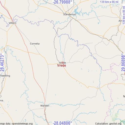
Vrede GPS coordinates[2]
27° 25' 32.628" South, 29° 9' 57.06" East
| Map corner | latitude | longitude |
|---|---|---|
| Upper-left | -26.79988°, | 28.46273° |
| Center: | -27.42573°, | 29.16585° |
| Lower-right: | -28.04806°, | 29.86898° |
| Map W x H: | 138.8×138.8 km | = 86.2×86.2mi |
| max Lat: | -22.34881° ⇑36% North |
| Vrede: | -27.42573° |
| min Lat: | ⇓64% South -34.66739° |
| min Long | Vrede | max Long |
| 16.8697° | 29.16585° | 32.26762° |
| W 70.5%⇐ | ⇒29.5% E |
Elevation
Elevation of Vrede is 1678 m = 5505 ft, and this is 708.4 m = 2324 ft above average elevation for this country.
| Max E: |
1873 m = 6145 ft | 3.2% |
| Vrede | 1678 m 5505 ft | |
| Avg. | 969.6 m = 3181 ft | |
Min E: |
7 m = 23 ft | 96.8% |
See also: South Africa elevation on elevation.city.
Geographical zone
Vrede is located in South temperate zone (between Tropic of Capricorn and the Antarctic Circle). Distance of this Southern Tropic circle is 443.5 km =275.6 mi to North.| Distance of | km | miles | from Vrede |
|---|---|---|---|
| Equator | 3049.5 | 1894.9 | to North |
| Tropic Capricorn | 443.5 | 275.6 | to North |
| Antarctic Circle | 4351.7 | 2704 | to South |
| South Pole | 6957.6 | 4323.3 | to South |


Nearby cities:
15 places around Vrede: (largest is in red/bold)
• Balfour
102.2 km =63.5 mi,  326°
326°
• Bethal
111.6 km =69.3 mi,  15°
15°
• Dannhauser
109.5 km =68 mi,  126°
126°
• Deneysville
121.3 km =75.4 mi,  299°
299°
• Frankfort
68 km =42.3 mi,  283°
283°
• Harrismith
94.2 km =58.5 mi,  182°
182°
• Heilbron
119.1 km =74 mi, 277°
• Newcastle
84 km =52.2 mi,  116°
116°
• Reitz
83.9 km =52.1 mi,  240°
240°
• Secunda
97.4 km =60.5 mi,  0°
0°
• Standerton
55.2 km =34.3 mi,  7°
7°
• Utrecht
116.9 km =72.6 mi,  102°
102°
• Villiers
71.1 km =44.2 mi,  308°
308°
• Volksrust
71 km =44.1 mi,  84°
84°
• eMbalenhle
99.7 km =62 mi,  354°
354°
Sources, notices
• [Note1] Compared only with cities in South Africa existing in our database
• [Src1] Map data: © OpenStreetMap contributors (CC-BY-SA)
• [Src2] Other city data from geonames.org with taken over terms of usage.
• [Src3] Geographical zone / Annual Mean Temperature by Robert A. Rohde @ Wikipedia
