Beaufort West geodata
Beaufort West (Western Cape) is a seat of a second-order administrative division; located in South Africa in Africa/Johannesburg (GMT+2) time zone. With population of 44,737 people, there are 98 cities with bigger population in this country. Compared to other cities in South Africa, 81.4% of cities are located further ↑North; 82.6% of cities are located further →East and 64.3% of cities have higher elevation than Beaufort West. Note1
Administrative division(s):
- Level 1: Western Cape
- Level 2: Central Karoo District Municipality
- Level 3: Beaufort West


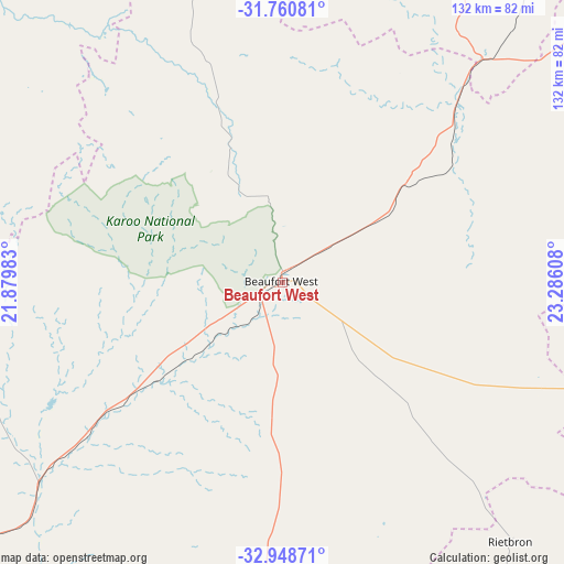
Beaufort West GPS coordinates[2]
32° 21' 24.156" South, 22° 34' 58.62" East
| Map corner | latitude | longitude |
|---|---|---|
| Upper-left | -31.76081°, | 21.87983° |
| Center: | -32.35671°, | 22.58295° |
| Lower-right: | -32.94871°, | 23.28608° |
| Map W x H: | 132.1×132.1 km | = 82.1×82.1mi |
| max Lat: | -22.34881° ⇑81.4% North |
| Beaufort West: | -32.35671° |
| min Lat: | ⇓18.6% South -34.66739° |
| min Long | Beaufort West | max Long |
| 16.8697° | 22.58295° | 32.26762° |
| W 17.4%⇐ | ⇒82.6% E |
Elevation
Elevation of Beaufort West is 849 m = 2785 ft, and this is 120.6 m = 396 ft below average elevation for this country.
| Max E: |
1873 m = 6145 ft | 64.3% |
| Avg. | 969.6 m = 3181 ft | |
| Beaufort West | 849 m = 2785 ft | |
Min E: |
7 m = 23 ft | 35.7% |
See also: Beaufort West elevation on elevation.city.
Geographical zone
Beaufort West is located in South temperate zone (between Tropic of Capricorn and the Antarctic Circle). Distance of this Southern Tropic circle is 991.8 km =616.3 mi to North.| Distance of | km | miles | from Beaufort West |
|---|---|---|---|
| Equator | 3597.7 | 2235.5 | to North |
| Tropic Capricorn | 991.8 | 616.3 | to North |
| Antarctic Circle | 3803.4 | 2363.3 | to South |
| South Pole | 6409.3 | 3982.6 | to South |


Nearby cities:
15 places around Beaufort West: (largest is in red/bold)
• Calitzdorp
155.3 km =96.5 mi,  213°
213°
• Carnarvon
160.1 km =99.5 mi,  344°
344°
• De Rust
126.1 km =78.4 mi,  182°
182°
• Fraserburg
112 km =69.6 mi,  295°
295°
• George
179 km =111.2 mi, 183°
• Graaff-Reinet
183.4 km =114 mi,  86°
86°
• Knysna
191.7 km =119.1 mi,  166°
166°
• Ladismith
176.2 km =109.5 mi,  224°
224°
• Laingsburg
186.2 km =115.7 mi,  239°
239°
• Oudtshoorn
142.8 km =88.7 mi,  194°
194°
• Prince Albert
109.6 km =68.1 mi, 208°
• Victoria West
117.3 km =72.9 mi,  25°
25°
• Williston
193.8 km =120.4 mi,  305°
305°
• Willowmore
134.2 km =83.4 mi,  140°
140°
• Zoar
165.3 km =102.7 mi, 220°
Sources, notices
• [Note1] Compared only with cities in South Africa existing in our database
• [Src1] Map data: © OpenStreetMap contributors (CC-BY-SA)
• [Src2] Other city data from geonames.org with taken over terms of usage.
• [Src3] Geographical zone / Annual Mean Temperature by Robert A. Rohde @ Wikipedia
