Plettenberg Bay geodata
Plettenberg Bay (Western Cape) is a seat of a third-order administrative division; located in South Africa in Africa/Johannesburg (GMT+2) time zone. With population of 19,445 people, there are 148 cities with bigger population in this country. Compared to other cities in South Africa, 97.3% of cities are located further ↑North; 80.8% of cities are located further →East and 90.6% of cities have higher elevation than Plettenberg Bay. Note1
Administrative division(s):
- Level 1: Western Cape
- Level 2: Eden District Municipality
- Level 3: Bitou


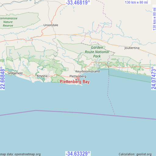
Plettenberg Bay GPS coordinates[2]
34° 3' 9.864" South, 23° 22' 17.76" East
| Map corner | latitude | longitude |
|---|---|---|
| Upper-left | -33.46819°, | 22.66848° |
| Center: | -34.05274°, | 23.3716° |
| Lower-right: | -34.63329°, | 24.07473° |
| Map W x H: | 129.5×129.5 km | = 80.5×80.5mi |
| max Lat: | -22.34881° ⇑97.3% North |
| Plettenberg Bay: | -34.05274° |
| min Lat: | ⇓2.7% South -34.66739° |
| min Long | Plettenberg Bay | max Long |
| 16.8697° | 23.3716° | 32.26762° |
| W 19.2%⇐ | ⇒80.8% E |
Elevation
Elevation of Plettenberg Bay is 77 m = 253 ft, and this is 892.6 m = 2928 ft below average elevation for this country.
| Max E: |
1873 m = 6145 ft | 90.6% |
| Avg. | 969.6 m = 3181 ft | |
| Plettenberg Bay | 77 m = 253 ft | |
Min E: |
7 m = 23 ft | 9.4% |
See also: South Africa elevation on elevation.city.
Geographical zone
Plettenberg Bay is located in South temperate zone (between Tropic of Capricorn and the Antarctic Circle). Distance of this Southern Tropic circle is 1180.4 km =733.5 mi to North.| Distance of | km | miles | from Plettenberg Bay |
|---|---|---|---|
| Equator | 3786.3 | 2352.7 | to North |
| Tropic Capricorn | 1180.4 | 733.5 | to North |
| Antarctic Circle | 3614.9 | 2246.2 | to South |
| South Pole | 6220.8 | 3865.4 | to South |


Nearby cities:
15 places around Plettenberg Bay: (largest is in red/bold)
• Albertina
165.8 km =103 mi,  264°
264°
• Calitzdorp
167.2 km =103.9 mi,  290°
290°
• De Rust
99.4 km =61.8 mi,  308°
308°
• George
84.5 km =52.5 mi,  276°
276°
• Jansenville
172.5 km =107.2 mi,  44°
44°
• Kareedouw
85.4 km =53.1 mi,  82°
82°
• Knysna
30 km =18.6 mi,  273°
273°
• Kruisfontein
125.4 km =77.9 mi,  87°
87°
• Mossel Bay
113.7 km =70.6 mi, 262°
• Oudtshoorn
119.4 km =74.2 mi, 294°
• Prince Albert
154.8 km =96.2 mi, 306°
• Riversdale
194.8 km =121 mi, 268°
• Uitenhage
189.8 km =117.9 mi, 80°
• Willowmore
85.2 km =52.9 mi,  7°
7°
• Zoar
188.6 km =117.2 mi, 289°
Sources, notices
• [Note1] Compared only with cities in South Africa existing in our database
• [Src1] Map data: © OpenStreetMap contributors (CC-BY-SA)
• [Src2] Other city data from geonames.org with taken over terms of usage.
• [Src3] Geographical zone / Annual Mean Temperature by Robert A. Rohde @ Wikipedia
