Kareedouw geodata
Kareedouw (Eastern Cape) is a seat of a third-order administrative division; located in South Africa in Africa/Johannesburg (GMT+2) time zone. In our database, there are 257 cities with bigger population. Compared to other cities in South Africa, 93.5% of cities are located further ↑North; 78.5% of cities are located further →East and 79.4% of cities have higher elevation than Kareedouw. Note1
Administrative division(s):
- Level 1: Eastern Cape
- Level 2: Cacadu District Municipality
- Level 3: Kou-Kamma


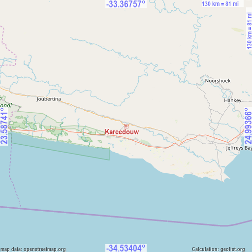
Kareedouw GPS coordinates[2]
33° 57' 10.08" South, 24° 17' 25.908" East
| Map corner | latitude | longitude |
|---|---|---|
| Upper-left | -33.36757°, | 23.58741° |
| Center: | -33.9528°, | 24.29053° |
| Lower-right: | -34.53404°, | 24.99366° |
| Map W x H: | 129.7×129.7 km | = 80.6×80.6mi |
| max Lat: | -22.34881° ⇑93.5% North |
| Kareedouw: | -33.9528° |
| min Lat: | ⇓6.5% South -34.66739° |
| min Long | Kareedouw | max Long |
| 16.8697° | 24.29053° | 32.26762° |
| W 21.5%⇐ | ⇒78.5% E |
Elevation
Elevation of Kareedouw is 328 m = 1076 ft, and this is 641.6 m = 2105 ft below average elevation for this country.
| Max E: |
1873 m = 6145 ft | 79.4% |
| Avg. | 969.6 m = 3181 ft | |
| Kareedouw | 328 m = 1076 ft | |
Min E: |
7 m = 23 ft | 20.6% |
See also: South Africa elevation on elevation.city.
Geographical zone
Kareedouw is located in South temperate zone (between Tropic of Capricorn and the Antarctic Circle). Distance of this Southern Tropic circle is 1169.3 km =726.6 mi to North.| Distance of | km | miles | from Kareedouw |
|---|---|---|---|
| Equator | 3775.2 | 2345.8 | to North |
| Tropic Capricorn | 1169.3 | 726.6 | to North |
| Antarctic Circle | 3626 | 2253.1 | to South |
| South Pole | 6231.9 | 3872.3 | to South |


Nearby cities:
15 places around Kareedouw: (largest is in red/bold)
• De Rust
170.3 km =105.8 mi,  287°
287°
• George
168.7 km =104.8 mi,  269°
269°
• Graaff-Reinet
190.4 km =118.3 mi,  6°
6°
• Grahamstown
219.8 km =136.6 mi,  70°
70°
• Jansenville
117.7 km =73.1 mi,  17°
17°
• Kirkwood
123.2 km =76.6 mi,  59°
59°
• Knysna
115 km =71.5 mi, 265°
• Kruisfontein
41 km =25.5 mi,  97°
97°
• Mossel Bay
199.2 km =123.8 mi,  262°
262°
• Oudtshoorn
197.2 km =122.5 mi,  281°
281°
• Plettenberg Bay
85.4 km =53.1 mi, 262°
• Port Elizabeth
122.1 km =75.9 mi,  90°
90°
• Somerset East
182.4 km =113.3 mi,  41°
41°
• Uitenhage
104.5 km =64.9 mi,  78°
78°
• Willowmore
104.3 km =64.8 mi,  314°
314°
Sources, notices
• [Note1] Compared only with cities in South Africa existing in our database
• [Src1] Map data: © OpenStreetMap contributors (CC-BY-SA)
• [Src2] Other city data from geonames.org with taken over terms of usage.
• [Src3] Geographical zone / Annual Mean Temperature by Robert A. Rohde @ Wikipedia
