Uitenhage geodata
Uitenhage (Eastern Cape) is a populated place; located in South Africa in Africa/Johannesburg (GMT+2) time zone. With population of 228,912 people, there are 24 cities with bigger population in this country. Compared to other cities in South Africa, 90.9% of cities are located further ↑North; 72% of cities are located further →East and 88.5% of cities have higher elevation than Uitenhage. Note1
Administrative division(s):
- Level 1: Eastern Cape
- Level 2: Nelson Mandela Bay Metropolitan Municipality
- Level 3: Nelson Mandela Bay


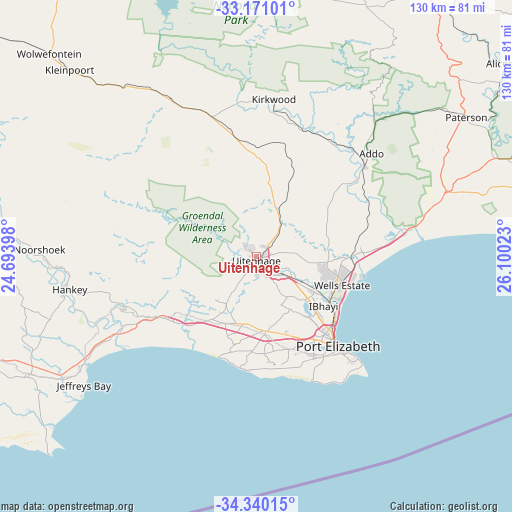
Uitenhage GPS coordinates[2]
33° 45' 27.252" South, 25° 23' 49.56" East
| Map corner | latitude | longitude |
|---|---|---|
| Upper-left | -33.17101°, | 24.69398° |
| Center: | -33.75757°, | 25.3971° |
| Lower-right: | -34.34015°, | 26.10023° |
| Map W x H: | 130×130 km | = 80.8×80.8mi |
| max Lat: | -22.34881° ⇑90.9% North |
| Uitenhage: | -33.75757° |
| min Lat: | ⇓9.1% South -34.66739° |
| min Long | Uitenhage | max Long |
| 16.8697° | 25.3971° | 32.26762° |
| W 28%⇐ | ⇒72% E |
Elevation
Elevation of Uitenhage is 103 m = 338 ft, and this is 866.6 m = 2843 ft below average elevation for this country.
| Max E: |
1873 m = 6145 ft | 88.5% |
| Avg. | 969.6 m = 3181 ft | |
| Uitenhage | 103 m = 338 ft | |
Min E: |
7 m = 23 ft | 11.5% |
See also: Uitenhage elevation on elevation.city.
Geographical zone
Uitenhage is located in South temperate zone (between Tropic of Capricorn and the Antarctic Circle). Distance of this Southern Tropic circle is 1147.6 km =713.1 mi to North.| Distance of | km | miles | from Uitenhage |
|---|---|---|---|
| Equator | 3753.5 | 2332.3 | to North |
| Tropic Capricorn | 1147.6 | 713.1 | to North |
| Antarctic Circle | 3647.7 | 2266.6 | to South |
| South Pole | 6253.6 | 3885.8 | to South |


Nearby cities:
15 places around Uitenhage: (largest is in red/bold)
• Adelaide
143.6 km =89.2 mi,  35°
35°
• Alice
171.7 km =106.7 mi,  51°
51°
• Cradock
178.4 km =110.9 mi,  6°
6°
• Fort Beaufort
158.6 km =98.5 mi, 46°
• Graaff-Reinet
185.9 km =115.5 mi,  334°
334°
• Grahamstown
116.7 km =72.5 mi,  64°
64°
• Jansenville
112.9 km =70.2 mi,  323°
323°
• Kareedouw
104.5 km =64.9 mi,  258°
258°
• Kirkwood
40.2 km =25 mi, 6°
• Kruisfontein
67.3 km =41.8 mi,  246°
246°
• Peddie
170.8 km =106.1 mi,  68°
68°
• Port Alfred
138.8 km =86.2 mi,  82°
82°
• Port Elizabeth
30.3 km =18.8 mi,  138°
138°
• Somerset East
116.5 km =72.4 mi, 8°
• Willowmore
184.2 km =114.5 mi,  286°
286°
Sources, notices
• [Note1] Compared only with cities in South Africa existing in our database
• [Src1] Map data: © OpenStreetMap contributors (CC-BY-SA)
• [Src2] Other city data from geonames.org with taken over terms of usage.
• [Src3] Geographical zone / Annual Mean Temperature by Robert A. Rohde @ Wikipedia
