Louis Trichardt geodata
Louis Trichardt (Limpopo) is a seat of a third-order administrative division; located in South Africa in Africa/Johannesburg (GMT+2) time zone. With population of 86,854 people, there are 61 cities with bigger population in this country. Compared to other cities in South Africa, 99.1% of cities are located further ↓South; 79.1% of cities are located further ←West and 59.3% of cities have higher elevation than Louis Trichardt. Note1


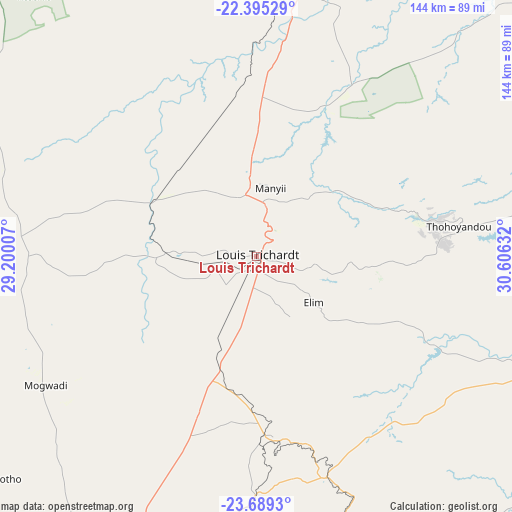
Louis Trichardt GPS coordinates[2]
23° 2' 37.86" South, 29° 54' 11.484" East
| Map corner | latitude | longitude |
|---|---|---|
| Upper-left | -22.39529°, | 29.20007° |
| Center: | -23.04385°, | 29.90319° |
| Lower-right: | -23.6893°, | 30.60632° |
| Map W x H: | 143.9×143.9 km | = 89.4×89.4mi |
| max Lat: | -22.34881° ⇑0.9% North |
| Louis Trichardt: | -23.04385° |
| min Lat: | ⇓99.1% South -34.66739° |
| min Long | Louis Trichardt | max Long |
| 16.8697° | 29.90319° | 32.26762° |
| W 79.1%⇐ | ⇒20.9% E |
Elevation
Elevation of Louis Trichardt is 956 m = 3136 ft, and this is 13.6 m = 45 ft below average elevation for this country.
| Max E: |
1873 m = 6145 ft | 59.3% |
| Avg. | 969.6 m = 3181 ft | |
| Louis Trichardt | 956 m = 3136 ft | |
Min E: |
7 m = 23 ft | 40.7% |
See also: Louis Trichardt elevation on elevation.city.
Geographical zone
Louis Trichardt is located in South Torrid zone (between Equator and Tropic of Capricorn). Distance of this Southern Tropic circle is 43.7 km =27.2 mi to South.| Distance of | km | miles | from Louis Trichardt |
|---|---|---|---|
| Equator | 2562.2 | 1592.1 | to North |
| Tropic Capricorn | 43.7 | 27.2 | to South |
| Antarctic Circle | 4838.9 | 3006.8 | to South |
| South Pole | 7444.8 | 4626 | to South |


Nearby cities:
15 places around Louis Trichardt: (largest is in red/bold)
• Apel
153.2 km =95.2 mi,  185°
185°
• Bochum
82.6 km =51.3 mi,  250°
250°
• Dendron
69.2 km =43 mi,  238°
238°
• Duiwelskloof
76.2 km =47.3 mi,  161°
161°
• Ga-Kgapane
74.3 km =46.2 mi,  153°
153°
• Giyani
88.2 km =54.8 mi,  109°
109°
• Lebowakgomo
135 km =83.9 mi,  197°
197°
• Mankoeng
95.6 km =59.4 mi, 185°
• Mokopane
157 km =97.6 mi,  215°
215°
• Musina
78.6 km =48.8 mi,  10°
10°
• Mutale
118.4 km =73.6 mi,  57°
57°
• Nkowakowa
101.7 km =63.2 mi, 157°
• Polokwane
105.4 km =65.5 mi, 204°
• Thohoyandou
60.5 km =37.6 mi,  79°
79°
• Tzaneen
91.7 km =57 mi, 163°
Sources, notices
• [Note1] Compared only with cities in South Africa existing in our database
• [Src1] Map data: © OpenStreetMap contributors (CC-BY-SA)
• [Src2] Other city data from geonames.org with taken over terms of usage.
• [Src3] Geographical zone / Annual Mean Temperature by Robert A. Rohde @ Wikipedia
