Apel geodata
Apel (Limpopo) is a seat of a third-order administrative division; located in South Africa in Africa/Johannesburg (GMT+2) time zone. In our database, there are 257 cities with bigger population. Compared to other cities in South Africa, 94.7% of cities are located further ↓South; 76.1% of cities are located further ←West and 67% of cities have higher elevation than Apel. Note1
Administrative division(s):
- Level 1: Limpopo
- Level 2: Sekhukhune District Municipality
- Level 3: Fetakgomo


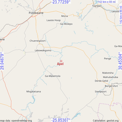
Apel GPS coordinates[2]
24° 24' 52.02" South, 29° 44' 59.676" East
| Map corner | latitude | longitude |
|---|---|---|
| Upper-left | -23.77259°, | 29.04679° |
| Center: | -24.41445°, | 29.74991° |
| Lower-right: | -25.05307°, | 30.45304° |
| Map W x H: | 142.4×142.4 km | = 88.5×88.5mi |
| max Lat: | -22.34881° ⇑5.3% North |
| Apel: | -24.41445° |
| min Lat: | ⇓94.7% South -34.66739° |
| min Long | Apel | max Long |
| 16.8697° | 29.74991° | 32.26762° |
| W 76.1%⇐ | ⇒23.9% E |
Elevation
Elevation of Apel is 768 m = 2520 ft, and this is 201.6 m = 661 ft below average elevation for this country.
| Max E: |
1873 m = 6145 ft | 67% |
| Avg. | 969.6 m = 3181 ft | |
| Apel | 768 m = 2520 ft | |
Min E: |
7 m = 23 ft | 33% |
See also: South Africa elevation on elevation.city.
Geographical zone
Apel is located in South temperate zone (between Tropic of Capricorn and the Antarctic Circle). Distance of this Southern Tropic circle is 108.7 km =67.5 mi to North.| Distance of | km | miles | from Apel |
|---|---|---|---|
| Equator | 2714.6 | 1686.8 | to North |
| Tropic Capricorn | 108.7 | 67.5 | to North |
| Antarctic Circle | 4686.5 | 2912.1 | to South |
| South Pole | 7292.4 | 4531.3 | to South |


Nearby cities:
15 places around Apel: (largest is in red/bold)
• Burgersfort
65.3 km =40.6 mi,  116°
116°
• Duiwelskloof
89.4 km =55.6 mi,  26°
26°
• Ga-Kgapane
98.3 km =61.1 mi, 29°
• Groblersdal
91.2 km =56.7 mi,  203°
203°
• Hoedspruit
122.1 km =75.9 mi,  86°
86°
• Jane Furse
40.3 km =25 mi,  162°
162°
• Lebowakgomo
34.8 km =21.6 mi,  313°
313°
• Lydenburg
103.2 km =64.1 mi,  137°
137°
• Mankoeng
57.6 km =35.8 mi,  6°
6°
• Marble Hall
76.9 km =47.8 mi,  217°
217°
• Mokopane
78.9 km =49 mi,  288°
288°
• Nkowakowa
80 km =49.7 mi,  42°
42°
• Polokwane
63.5 km =39.5 mi,  333°
333°
• Siyabuswa
105.4 km =65.5 mi, 222°
• Tzaneen
77.1 km =47.9 mi, 33°
Sources, notices
• [Note1] Compared only with cities in South Africa existing in our database
• [Src1] Map data: © OpenStreetMap contributors (CC-BY-SA)
• [Src2] Other city data from geonames.org with taken over terms of usage.
• [Src3] Geographical zone / Annual Mean Temperature by Robert A. Rohde @ Wikipedia
