Viljoenskroon geodata
Viljoenskroon (Orange Free State) is a populated place; located in South Africa in Africa/Johannesburg (GMT+2) time zone. With population of 54,955 people, there are 90 cities with bigger population in this country. Compared to other cities in South Africa, 66.4% of cities are located further ↓South; 59.3% of cities are located further →East and 68.4% of cities have lower elevation than Viljoenskroon. Note1
Administrative division(s):
- Level 1: Orange Free State
- Level 2: Fezile Dabi District Municipality
- Level 3: Moqhaka


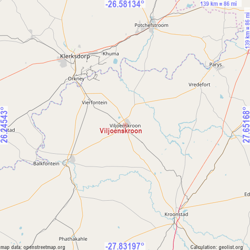
Viljoenskroon GPS coordinates[2]
27° 12' 30.276" South, 26° 56' 54.78" East
| Map corner | latitude | longitude |
|---|---|---|
| Upper-left | -26.58134°, | 26.24543° |
| Center: | -27.20841°, | 26.94855° |
| Lower-right: | -27.83197°, | 27.65168° |
| Map W x H: | 139.1×139.1 km | = 86.4×86.4mi |
| max Lat: | -22.34881° ⇑33.6% North |
| Viljoenskroon: | -27.20841° |
| min Lat: | ⇓66.4% South -34.66739° |
| min Long | Viljoenskroon | max Long |
| 16.8697° | 26.94855° | 32.26762° |
| W 40.7%⇐ | ⇒59.3% E |
Elevation
Elevation of Viljoenskroon is 1345 m = 4413 ft, and this is 375.4 m = 1232 ft above average elevation for this country.
| Max E: |
1873 m = 6145 ft | 31.6% |
| Viljoenskroon | 1345 m 4413 ft | |
| Avg. | 969.6 m = 3181 ft | |
Min E: |
7 m = 23 ft | 68.4% |
See also: Viljoenskroon elevation on elevation.city.
Geographical zone
Viljoenskroon is located in South temperate zone (between Tropic of Capricorn and the Antarctic Circle). Distance of this Southern Tropic circle is 419.4 km =260.6 mi to North.| Distance of | km | miles | from Viljoenskroon |
|---|---|---|---|
| Equator | 3025.3 | 1879.8 | to North |
| Tropic Capricorn | 419.4 | 260.6 | to North |
| Antarctic Circle | 4375.9 | 2719.1 | to South |
| South Pole | 6981.8 | 4338.3 | to South |


Nearby cities:
15 places around Viljoenskroon: (largest is in red/bold)
• Allanridge
67.7 km =42.1 mi,  206°
206°
• Bothaville
38.4 km =23.9 mi,  238°
238°
• Hennenman
85.7 km =53.3 mi,  175°
175°
• Klerksdorp
48.5 km =30.1 mi,  324°
324°
• Koppies
62 km =38.5 mi,  93°
93°
• Kroonstad
56.7 km =35.2 mi,  150°
150°
• Kutloanong
72.2 km =44.9 mi,  195°
195°
• Orkney
37.3 km =23.2 mi,  312°
312°
• Parys
60.7 km =37.7 mi,  56°
56°
• Potchefstroom
56.7 km =35.2 mi,  15°
15°
• Stilfontein
44.2 km =27.5 mi,  336°
336°
• Vredefort
46.8 km =29.1 mi, 61°
• Welkom
88.1 km =54.7 mi,  193°
193°
• Wesselsbron
92 km =57.2 mi,  218°
218°
• Wolmaransstad
95.5 km =59.3 mi,  270°
270°
Sources, notices
• [Note1] Compared only with cities in South Africa existing in our database
• [Src1] Map data: © OpenStreetMap contributors (CC-BY-SA)
• [Src2] Other city data from geonames.org with taken over terms of usage.
• [Src3] Geographical zone / Annual Mean Temperature by Robert A. Rohde @ Wikipedia
