Bothaville geodata
Bothaville (Orange Free State) is a seat of a third-order administrative division; located in South Africa in Africa/Johannesburg (GMT+2) time zone. With population of 71,934 people, there are 70 cities with bigger population in this country. Compared to other cities in South Africa, 64.6% of cities are located further ↓South; 65.2% of cities are located further →East and 61.9% of cities have lower elevation than Bothaville. Note1
Administrative division(s):
- Level 1: Orange Free State
- Level 2: Lejweleputswa District Municipality
- Level 3: Nala


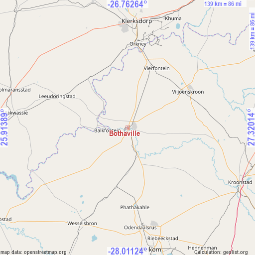
Bothaville GPS coordinates[2]
27° 23' 19.32" South, 26° 37' 1.236" East
| Map corner | latitude | longitude |
|---|---|---|
| Upper-left | -26.76264°, | 25.91389° |
| Center: | -27.3887°, | 26.61701° |
| Lower-right: | -28.01124°, | 27.32014° |
| Map W x H: | 138.8×138.8 km | = 86.2×86.2mi |
| max Lat: | -22.34881° ⇑35.4% North |
| Bothaville: | -27.3887° |
| min Lat: | ⇓64.6% South -34.66739° |
| min Long | Bothaville | max Long |
| 16.8697° | 26.61701° | 32.26762° |
| W 34.8%⇐ | ⇒65.2% E |
Elevation
Elevation of Bothaville is 1276 m = 4186 ft, and this is 306.4 m = 1005 ft above average elevation for this country.
| Max E: |
1873 m = 6145 ft | 38.1% |
| Bothaville | 1276 m 4186 ft | |
| Avg. | 969.6 m = 3181 ft | |
Min E: |
7 m = 23 ft | 61.9% |
See also: Bothaville elevation on elevation.city.
Geographical zone
Bothaville is located in South temperate zone (between Tropic of Capricorn and the Antarctic Circle). Distance of this Southern Tropic circle is 439.4 km =273 mi to North.| Distance of | km | miles | from Bothaville |
|---|---|---|---|
| Equator | 3045.3 | 1892.3 | to North |
| Tropic Capricorn | 439.4 | 273 | to North |
| Antarctic Circle | 4355.8 | 2706.6 | to South |
| South Pole | 6961.7 | 4325.8 | to South |


Nearby cities:
15 places around Bothaville: (largest is in red/bold)
• Allanridge
40.7 km =25.3 mi,  176°
176°
• Hennenman
76.7 km =47.7 mi,  148°
148°
• Hoopstad
85.5 km =53.1 mi,  234°
234°
• Klerksdorp
59.9 km =37.2 mi,  4°
4°
• Kroonstad
67.5 km =41.9 mi,  115°
115°
• Kutloanong
51.1 km =31.8 mi,  165°
165°
• Orkney
45.8 km =28.5 mi,  6°
6°
• Potchefstroom
88.7 km =55.1 mi,  32°
32°
• Stilfontein
62.3 km =38.7 mi, 13°
• Viljoenskroon
38.4 km =23.9 mi,  58°
58°
• Virginia
83.2 km =51.7 mi,  162°
162°
• Vredefort
85.2 km =52.9 mi, 60°
• Welkom
66.5 km =41.3 mi, 169°
• Wesselsbron
57.4 km =35.7 mi,  205°
205°
• Wolmaransstad
66.1 km =41.1 mi,  288°
288°
Sources, notices
• [Note1] Compared only with cities in South Africa existing in our database
• [Src1] Map data: © OpenStreetMap contributors (CC-BY-SA)
• [Src2] Other city data from geonames.org with taken over terms of usage.
• [Src3] Geographical zone / Annual Mean Temperature by Robert A. Rohde @ Wikipedia
