eMbalenhle geodata
eMbalenhle (Mpumalanga) is a populated place; located in South Africa in Africa/Johannesburg (GMT+2) time zone. With population of 141,741 people, there are 36 cities with bigger population in this country. Compared to other cities in South Africa, 73.2% of cities are located further ↓South; 69.6% of cities are located further ←West and 87.3% of cities have lower elevation than eMbalenhle. Note1
Administrative division(s):
- Level 1: Mpumalanga
- Level 2: Gert Sibande District Municipality
- Level 3: Govan Mbeki


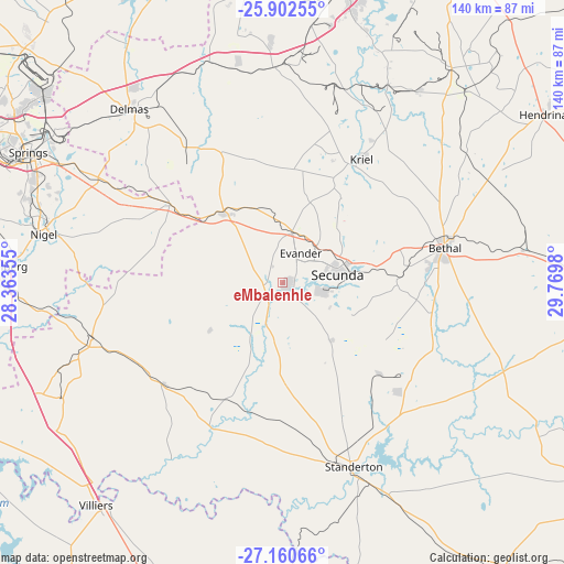
eMbalenhle GPS coordinates[2]
26° 31' 59.988" South, 29° 4' 0.012" East
| Map corner | latitude | longitude |
|---|---|---|
| Upper-left | -25.90255°, | 28.36355° |
| Center: | -26.53333°, | 29.06667° |
| Lower-right: | -27.16066°, | 29.7698° |
| Map W x H: | 139.9×139.9 km | = 86.9×86.9mi |
| max Lat: | -22.34881° ⇑26.8% North |
| eMbalenhle: | -26.53333° |
| min Lat: | ⇓73.2% South -34.66739° |
| min Long | eMbalenhle | max Long |
| 16.8697° | 29.06667° | 32.26762° |
| W 69.6%⇐ | ⇒30.4% E |
Elevation
Elevation of eMbalenhle is 1575 m = 5167 ft, and this is 605.4 m = 1986 ft above average elevation for this country.
| Max E: |
1873 m = 6145 ft | 12.7% |
| eMbalenhle | 1575 m 5167 ft | |
| Avg. | 969.6 m = 3181 ft | |
Min E: |
7 m = 23 ft | 87.3% |
See also: eMbalenhle elevation on elevation.city.
Geographical zone
eMbalenhle is located in South temperate zone (between Tropic of Capricorn and the Antarctic Circle). Distance of this Southern Tropic circle is 344.3 km =213.9 mi to North.| Distance of | km | miles | from eMbalenhle |
|---|---|---|---|
| Equator | 2950.2 | 1833.2 | to North |
| Tropic Capricorn | 344.3 | 213.9 | to North |
| Antarctic Circle | 4450.9 | 2765.7 | to South |
| South Pole | 7056.8 | 4384.9 | to South |


Nearby cities:
15 places around eMbalenhle: (largest is in red/bold)
• Balfour
49.5 km =30.8 mi,  253°
253°
• Benoni
83.6 km =51.9 mi,  297°
297°
• Bethal
40.6 km =25.2 mi,  78°
78°
• Brakpan
76.9 km =47.8 mi, 295°
• Bronkhorstspruit
86.7 km =53.9 mi,  338°
338°
• Delmas
57.5 km =35.7 mi,  318°
318°
• Heidelberg
70.5 km =43.8 mi,  272°
272°
• Hendrina
76.9 km =47.8 mi,  57°
57°
• Kriel
32.9 km =20.4 mi,  28°
28°
• Nigel
59.8 km =37.2 mi,  280°
280°
• Secunda
10.1 km =6.3 mi,  100°
100°
• Springs
73.5 km =45.7 mi, 295°
• Standerton
47.8 km =29.7 mi,  158°
158°
• Villiers
72.1 km =44.8 mi,  219°
219°
• Witbank
75.5 km =46.9 mi,  12°
12°
Sources, notices
• [Note1] Compared only with cities in South Africa existing in our database
• [Src1] Map data: © OpenStreetMap contributors (CC-BY-SA)
• [Src2] Other city data from geonames.org with taken over terms of usage.
• [Src3] Geographical zone / Annual Mean Temperature by Robert A. Rohde @ Wikipedia
