Boshof geodata
Boshof (Orange Free State) is a seat of a third-order administrative division; located in South Africa in Africa/Johannesburg (GMT+2) time zone. In our database, there are 257 cities with bigger population. Compared to other cities in South Africa, 50.1% of cities are located further ↓South; 72.6% of cities are located further →East and 60.8% of cities have lower elevation than Boshof. Note1
Administrative division(s):
- Level 1: Orange Free State
- Level 2: Lejweleputswa District Municipality
- Level 3: Tokologo


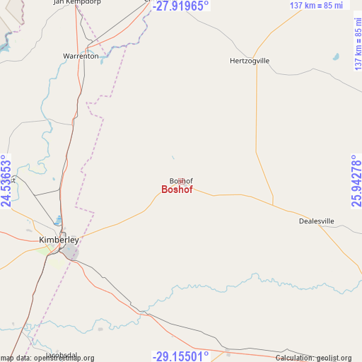
Boshof GPS coordinates[2]
28° 32' 20.904" South, 25° 14' 22.74" East
| Map corner | latitude | longitude |
|---|---|---|
| Upper-left | -27.91965°, | 24.53653° |
| Center: | -28.53914°, | 25.23965° |
| Lower-right: | -29.15501°, | 25.94278° |
| Map W x H: | 137.4×137.4 km | = 85.4×85.4mi |
| max Lat: | -22.34881° ⇑49.9% North |
| Boshof: | -28.53914° |
| min Lat: | ⇓50.1% South -34.66739° |
| min Long | Boshof | max Long |
| 16.8697° | 25.23965° | 32.26762° |
| W 27.4%⇐ | ⇒72.6% E |
Elevation
Elevation of Boshof is 1254 m = 4114 ft, and this is 284.4 m = 933 ft above average elevation for this country.
| Max E: |
1873 m = 6145 ft | 39.2% |
| Boshof | 1254 m 4114 ft | |
| Avg. | 969.6 m = 3181 ft | |
Min E: |
7 m = 23 ft | 60.8% |
See also: South Africa elevation on elevation.city.
Geographical zone
Boshof is located in South temperate zone (between Tropic of Capricorn and the Antarctic Circle). Distance of this Southern Tropic circle is 567.3 km =352.5 mi to North.| Distance of | km | miles | from Boshof |
|---|---|---|---|
| Equator | 3173.3 | 1971.8 | to North |
| Tropic Capricorn | 567.3 | 352.5 | to North |
| Antarctic Circle | 4227.9 | 2627.1 | to South |
| South Pole | 6833.8 | 4246.3 | to South |


Nearby cities:
15 places around Boshof: (largest is in red/bold)
• Barkly West
70.1 km =43.6 mi,  270°
270°
• Bloemfontein
114.9 km =71.4 mi,  124°
124°
• Bloemhof
105.6 km =65.6 mi,  19°
19°
• Brandfort
120.4 km =74.8 mi,  98°
98°
• Bultfontein
93.3 km =58 mi,  72°
72°
• Christiana
69.9 km =43.4 mi,  353°
353°
• Hartswater
97.9 km =60.8 mi,  333°
333°
• Hoopstad
102.3 km =63.6 mi,  39°
39°
• Jan Kempdorp
79.4 km =49.3 mi, 329°
• Kimberley
51.3 km =31.9 mi,  245°
245°
• Koffiefontein
99.2 km =61.6 mi,  193°
193°
• Pampierstad
100 km =62.1 mi, 327°
• Ritchie
83.2 km =51.7 mi,  228°
228°
• Taung
120.6 km =74.9 mi,  338°
338°
• Warrenton
60.9 km =37.8 mi,  320°
320°
Sources, notices
• [Note1] Compared only with cities in South Africa existing in our database
• [Src1] Map data: © OpenStreetMap contributors (CC-BY-SA)
• [Src2] Other city data from geonames.org with taken over terms of usage.
• [Src3] Geographical zone / Annual Mean Temperature by Robert A. Rohde @ Wikipedia
