Khōst geodata
Khōst (Khowst) is a seat of a first-order administrative division; located in Afghanistan in Asia/Kabul (GMT+4.5) time zone. With population of 96,123 people, there are 10 cities with bigger population in this country. Compared to other cities in Afghanistan, 76.5% of cities are located further ↑North; 81.4% of cities are located further ←West and 58.8% of cities have higher elevation than Khōst. Note1


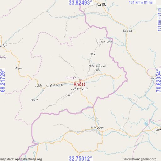
Khōst GPS coordinates[2]
33° 20' 22.236" North, 69° 55' 13.476" East
| Map corner | latitude | longitude |
|---|---|---|
| Upper-left | 33.92493°, | 69.21729° |
| Center: | 33.33951°, | 69.92041° |
| Lower-right: | 32.75012°, | 70.62354° |
| Map W x H: | 130.6×130.6 km | = 81.2×81.2mi |
| max Lat: | 38.4435° ⇑76.5% North |
| Khōst: | 33.33951° |
| min Lat: | ⇓23.5% South 30.15° |
| min Long | Khōst | max Long |
| 61.06667° | 69.92041° | 72.318° |
| W 81.4%⇐ | ⇒18.6% E |
Elevation
Elevation of Khōst is 1183 m = 3881 ft, and this is 235.4 m = 772 ft below average elevation for this country.
| Max E: |
3068 m = 10066 ft | 58.8% |
| Avg. | 1418.4 m = 4654 ft | |
| Khōst | 1183 m = 3881 ft | |
Min E: |
254 m = 833 ft | 41.2% |
See also: Khōst elevation on elevation.city.
Geographical zone
Khōst is located in North temperate zone (between Tropic of Cancer and the Arctic Circle). Distance of this Northern Tropic circle is 1101.1 km =684.2 mi to South.| Distance of | km | miles | from Khōst |
|---|---|---|---|
| North Pole | 6300.1 | 3914.7 | to North |
| Arctic Circle | 3694.2 | 2295.5 | to North |
| Tropic Cancer | 1101.1 | 684.2 | to South |
| Equator | 3707 | 2303.4 | to South |


Nearby cities:
15 places around Khōst: (largest is in red/bold)
• Dwah Manḏay
31.8 km =19.8 mi,  258°
258°
• Khulbisāt
19 km =11.8 mi,  24°
24°
• Maīdān Khūlah
36.8 km =22.9 mi,  339°
339°
• Nīkêh
62.6 km =38.9 mi,  254°
254°
• Salām Khēl
66 km =41 mi,  303°
303°
• Shaykh Amīr Kêlay
5.8 km =3.6 mi,  186°
186°
• Shwāk
51.3 km =31.9 mi,  280°
280°
• Spērah
40.7 km =25.3 mi, 247°
• Stêr Giyān
65 km =40.4 mi,  231°
231°
• Tsamkanī
52.4 km =32.6 mi,  349°
349°
• Tsapêraī
54.5 km =33.9 mi,  359°
359°
• Wulêswālī Sayyid Karam
64.3 km =40 mi,  307°
307°
• Zerok-Alakadari
60 km =37.3 mi, 250°
• Zorkot
28.3 km =17.6 mi,  322°
322°
• ‘Alī Shēr ‘Alāqahdārī
17.4 km =10.8 mi,  51°
51°
Sources, notices
• [Note1] Compared only with cities in Afghanistan existing in our database
• [Src1] Map data: © OpenStreetMap contributors (CC-BY-SA)
• [Src2] Other city data from geonames.org with taken over terms of usage.
• [Src3] Geographical zone / Annual Mean Temperature by Robert A. Rohde @ Wikipedia
