Wulêswālī Sayyid Karam geodata
Wulêswālī Sayyid Karam (Paktia) is a seat of a second-order administrative division; located in Afghanistan in Asia/Kabul (GMT+4.5) time zone. In our database, there are 93 cities with bigger population. Compared to other cities in Afghanistan, 70.4% of cities are located further ↑North; 70.1% of cities are located further ←West and 92.6% of cities have lower elevation than Wulêswālī Sayyid Karam. Note1
Current local time in Wulêswālī Sayyid Karam:
12:37 AM, WednesdayDifference from your time zone: hours


Wulêswālī Sayyid Karam GPS coordinates[2]
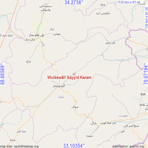
33° 41' 26.016" North, 69° 22' 7.716" East
| Map corner | latitude | longitude |
|---|---|---|
| Upper-left | 34.2736°, | 68.66569° |
| Center: | 33.69056°, | 69.36881° |
| Lower-right: | 33.10354°, | 70.07194° |
| Map W x H: | 130.1×130.1 km | = 80.8×80.8mi |
| max Lat: | 38.4435° ⇑70.4% North |
| Wulêswālī Sayyid Karam: | 33.69056° |
| min Lat: | ⇓29.6% South 30.15° |
| min Long | Wulêswālī Sa | max Long |
| 61.06667° | 69.36881° | 72.318° |
| W 70.1%⇐ | ⇒29.9% E |
Elevation
Elevation of Wulêswālī Sayyid Karam is 2458 m = 8064 ft, and this is 1039.6 m = 3411 ft above average elevation for this country.
| Max E: |
3068 m = 10066 ft | 7.4% |
| Wulêswālī Sayyid Karam | 2458 m 8064 ft | |
| Avg. | 1418.4 m = 4654 ft | |
Min E: |
254 m = 833 ft | 92.6% |
See also: Afghanistan elevation on elevation.city.
Geographical zone
Wulêswālī Sayyid Karam is located in North temperate zone (between Tropic of Cancer and the Arctic Circle). Distance of this Northern Tropic circle is 1140.1 km =708.4 mi to South.| Distance of | km | miles | from Wulêswālī Sayyid Karam |
|---|---|---|---|
| North Pole | 6261 | 3890.4 | to North |
| Arctic Circle | 3655.1 | 2271.2 | to North |
| Tropic Cancer | 1140.1 | 708.4 | to South |
| Equator | 3746 | 2327.7 | to South |


Nearby cities:
15 places around Wulêswālī Sayyid Karam: (largest is in red/bold)
• Baraki Barak
49.5 km =30.8 mi,  308°
308°
• Charkh
41.6 km =25.8 mi,  286°
286°
• Dwah Manḏay
49.7 km =30.9 mi,  156°
156°
• Gardez
16.8 km =10.4 mi,  231°
231°
• Khōshī
37.1 km =23.1 mi,  337°
337°
• Maīdān Khūlah
38.4 km =23.9 mi,  96°
96°
• Pul-e ‘Alam
46.6 km =29 mi,  316°
316°
• Salām Khēl
4.2 km =2.6 mi,  238°
238°
• Shwāk
29.7 km =18.5 mi,  178°
178°
• Spērah
56 km =34.8 mi,  165°
165°
• Tsamkanī
43.3 km =26.9 mi,  73°
73°
• Tsapêraī
53.2 km =33.1 mi, 73°
• Zorkot
37.7 km =23.4 mi,  116°
116°
• Zurmat
42.3 km =26.3 mi, 228°
• ‘Alī Khēl
42.8 km =26.6 mi,  49°
49°
Sources, notices
• [Note1] Compared only with cities in Afghanistan existing in our database
• [Src1] Map data: © OpenStreetMap contributors (CC-BY-SA)
• [Src2] Other city data from geonames.org with taken over terms of usage.
• [Src3] Geographical zone / Annual Mean Temperature by Robert A. Rohde @ Wikipedia
