Tsamkanī geodata
Tsamkanī (Paktia) is a seat of a second-order administrative division; located in Afghanistan in Asia/Kabul (GMT+4.5) time zone. In our database, there are 93 cities with bigger population. Compared to other cities in Afghanistan, 69.1% of cities are located further ↑North; 79.7% of cities are located further ←West and 62.7% of cities have lower elevation than Tsamkanī. Note1


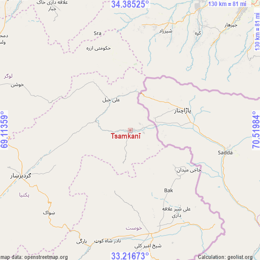
Tsamkanī GPS coordinates[2]
33° 48' 10.728" North, 69° 49' 0.156" East
| Map corner | latitude | longitude |
|---|---|---|
| Upper-left | 34.38525°, | 69.11359° |
| Center: | 33.80298°, | 69.81671° |
| Lower-right: | 33.21673°, | 70.51984° |
| Map W x H: | 129.9×129.9 km | = 80.7×80.7mi |
| max Lat: | 38.4435° ⇑69.1% North |
| Tsamkanī: | 33.80298° |
| min Lat: | ⇓30.9% South 30.15° |
| min Long | Tsamkanī | max Long |
| 61.06667° | 69.81671° | 72.318° |
| W 79.7%⇐ | ⇒20.3% E |
Elevation
Elevation of Tsamkanī is 1716 m = 5630 ft, and this is 297.6 m = 976 ft above average elevation for this country.
| Max E: |
3068 m = 10066 ft | 37.3% |
| Tsamkanī | 1716 m 5630 ft | |
| Avg. | 1418.4 m = 4654 ft | |
Min E: |
254 m = 833 ft | 62.7% |
See also: Afghanistan elevation on elevation.city.
Geographical zone
Tsamkanī is located in North temperate zone (between Tropic of Cancer and the Arctic Circle). Distance of this Northern Tropic circle is 1152.6 km =716.2 mi to South.| Distance of | km | miles | from Tsamkanī |
|---|---|---|---|
| North Pole | 6248.5 | 3882.6 | to North |
| Arctic Circle | 3642.6 | 2263.4 | to North |
| Tropic Cancer | 1152.6 | 716.2 | to South |
| Equator | 3758.5 | 2335.4 | to South |


Nearby cities:
15 places around Tsamkanī: (largest is in red/bold)
• Gardez
59.2 km =36.8 mi,  247°
247°
• Kaz̲h̲ah
59.2 km =36.8 mi,  34°
34°
• Khulbisāt
38.5 km =23.9 mi,  152°
152°
• Khōst
52.4 km =32.6 mi,  169°
169°
• Maīdān Khūlah
17.4 km =10.8 mi,  190°
190°
• Māmā Khēl
51.9 km =32.2 mi,  18°
18°
• Salām Khēl
47.4 km =29.5 mi, 251°
• Shaykh Amīr Kêlay
58 km =36 mi, 171°
• Shwāk
58.6 km =36.4 mi,  224°
224°
• Tsapêraī
9.9 km =6.2 mi,  72°
72°
• Wulêswālī Sayyid Karam
43.3 km =26.9 mi, 253°
• Zorkot
30.1 km =18.7 mi, 194°
• Ḩukūmatī Azrah
44.1 km =27.4 mi,  339°
339°
• ‘Alī Khēl
17.9 km =11.1 mi,  329°
329°
• ‘Alī Shēr ‘Alāqahdārī
46.9 km =29.1 mi, 150°
Sources, notices
• [Note1] Compared only with cities in Afghanistan existing in our database
• [Src1] Map data: © OpenStreetMap contributors (CC-BY-SA)
• [Src2] Other city data from geonames.org with taken over terms of usage.
• [Src3] Geographical zone / Annual Mean Temperature by Robert A. Rohde @ Wikipedia
