Mandōl geodata
Mandōl (Nuristan) is a seat of a second-order administrative division; located in Afghanistan in Asia/Kabul (GMT+4.5) time zone. In our database, there are 93 cities with bigger population. Compared to other cities in Afghanistan, 65.6% of cities are located further ↓South; 83.9% of cities are located further ←West and 74% of cities have lower elevation than Mandōl. Note1


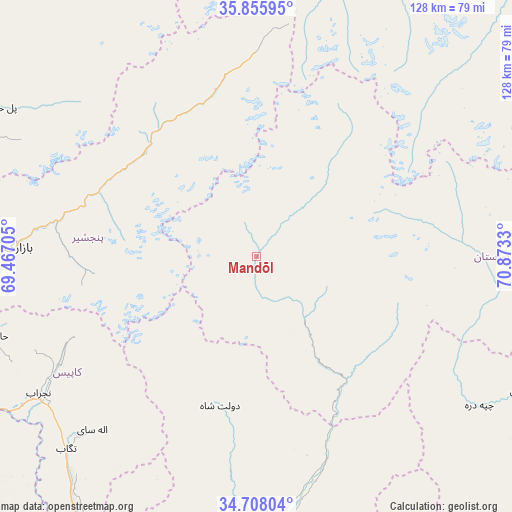
Mandōl GPS coordinates[2]
35° 17' 2.508" North, 70° 10' 12.612" East
| Map corner | latitude | longitude |
|---|---|---|
| Upper-left | 35.85595°, | 69.46705° |
| Center: | 35.28403°, | 70.17017° |
| Lower-right: | 34.70804°, | 70.8733° |
| Map W x H: | 127.6×127.6 km | = 79.3×79.3mi |
| max Lat: | 38.4435° ⇑34.4% North |
| Mandōl: | 35.28403° |
| min Lat: | ⇓65.6% South 30.15° |
| min Long | Mandōl | max Long |
| 61.06667° | 70.17017° | 72.318° |
| W 83.9%⇐ | ⇒16.1% E |
Elevation
Elevation of Mandōl is 2003 m = 6572 ft, and this is 584.6 m = 1918 ft above average elevation for this country.
| Max E: |
3068 m = 10066 ft | 26% |
| Mandōl | 2003 m 6572 ft | |
| Avg. | 1418.4 m = 4654 ft | |
Min E: |
254 m = 833 ft | 74% |
See also: Afghanistan elevation on elevation.city.
Geographical zone
Mandōl is located in North temperate zone (between Tropic of Cancer and the Arctic Circle). Distance of this Northern Tropic circle is 1317.3 km =818.5 mi to South.| Distance of | km | miles | from Mandōl |
|---|---|---|---|
| North Pole | 6083.8 | 3780.3 | to North |
| Arctic Circle | 3478 | 2161.1 | to North |
| Tropic Cancer | 1317.3 | 818.5 | to South |
| Equator | 3923.2 | 2437.8 | to South |


Nearby cities:
15 places around Mandōl: (largest is in red/bold)
• Alah Sāy
59.4 km =36.9 mi,  223°
223°
• Bāzārak
59.5 km =37 mi,  273°
273°
• Dowlat Shāh
38.2 km =23.7 mi,  193°
193°
• Kanḏay
66.5 km =41.3 mi,  123°
123°
• Khinj
42.6 km =26.5 mi,  292°
292°
• Kirāmān
44.4 km =27.6 mi, 271°
• Mehtar Lām
68.2 km =42.4 mi,  176°
176°
• Now Dahānak
40.6 km =25.2 mi,  338°
338°
• Pul-e Ḩişār
73.4 km =45.6 mi,  300°
300°
• Pārūn
69.9 km =43.4 mi,  77°
77°
• Shērwānī-ye Bālā
59.9 km =37.2 mi,  240°
240°
• Tagāb
67.3 km =41.8 mi, 224°
• Wuluswālī ‘Alīngār
52.8 km =32.8 mi,  160°
160°
• Ḩājī Khēl
69.7 km =43.3 mi,  253°
253°
• ’Unābah
72.2 km =44.9 mi, 265°
Sources, notices
• [Note1] Compared only with cities in Afghanistan existing in our database
• [Src1] Map data: © OpenStreetMap contributors (CC-BY-SA)
• [Src2] Other city data from geonames.org with taken over terms of usage.
• [Src3] Geographical zone / Annual Mean Temperature by Robert A. Rohde @ Wikipedia
