Markaz-e Sayyidābād geodata
Markaz-e Sayyidābād (Vardak) is a seat of a second-order administrative division; located in Afghanistan in Asia/Kabul (GMT+4.5) time zone. In our database, there are 93 cities with bigger population. Compared to other cities in Afghanistan, 65.9% of cities are located further ↑North; 52.7% of cities are located further ←West and 78.5% of cities have lower elevation than Markaz-e Sayyidābād. Note1


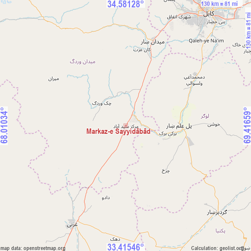
Markaz-e Sayyidābād GPS coordinates[2]
34° 0' 1.332" North, 68° 42' 48.456" East
| Map corner | latitude | longitude |
|---|---|---|
| Upper-left | 34.58128°, | 68.01034° |
| Center: | 34.00037°, | 68.71346° |
| Lower-right: | 33.41546°, | 69.41659° |
| Map W x H: | 129.6×129.6 km | = 80.5×80.5mi |
| max Lat: | 38.4435° ⇑65.9% North |
| Markaz-e Sayyidābād: | 34.00037° |
| min Lat: | ⇓34.1% South 30.15° |
| min Long | Markaz-e Sayyid | max Long |
| 61.06667° | 68.71346° | 72.318° |
| W 52.7%⇐ | ⇒47.3% E |
Elevation
Elevation of Markaz-e Sayyidābād is 2113 m = 6932 ft, and this is 694.6 m = 2279 ft above average elevation for this country.
| Max E: |
3068 m = 10066 ft | 21.5% |
| Markaz-e Sayyidābād | 2113 m 6932 ft | |
| Avg. | 1418.4 m = 4654 ft | |
Min E: |
254 m = 833 ft | 78.5% |
See also: Afghanistan elevation on elevation.city.
Geographical zone
Markaz-e Sayyidābād is located in North temperate zone (between Tropic of Cancer and the Arctic Circle). Distance of this Northern Tropic circle is 1174.6 km =729.9 mi to South.| Distance of | km | miles | from Markaz-e Sayyidābād |
|---|---|---|---|
| North Pole | 6226.6 | 3869 | to North |
| Arctic Circle | 3620.7 | 2249.8 | to North |
| Tropic Cancer | 1174.6 | 729.9 | to South |
| Equator | 3780.5 | 2349.1 | to South |


Nearby cities:
15 places around Markaz-e Sayyidābād: (largest is in red/bold)
• Baraki Barak
22 km =13.7 mi,  99°
99°
• Chahār Qal‘ah
62.9 km =39.1 mi,  217°
217°
• Charkh
30.6 km =19 mi,  137°
137°
• Gardez
65.2 km =40.5 mi,  133°
133°
• Ghazni
56.5 km =35.1 mi,  208°
208°
• Jalrēz
52.6 km =32.7 mi,  354°
354°
• Kalān Deh
34 km =21.1 mi,  237°
237°
• Khōshī
46.3 km =28.8 mi,  90°
90°
• Maydanshakhr
46.1 km =28.6 mi,  17°
17°
• Muḩammad Āghah Wuluswālī
42.8 km =26.6 mi,  56°
56°
• Mīrān
44.3 km =27.5 mi,  303°
303°
• Pul-e ‘Alam
28.5 km =17.7 mi, 91°
• Qal‘ah-ye Na‘īm
60.9 km =37.8 mi,  43°
43°
• Rāmak
53.8 km =33.4 mi,  188°
188°
• Tōrmay
45.1 km =28 mi, 219°
Sources, notices
• [Note1] Compared only with cities in Afghanistan existing in our database
• [Src1] Map data: © OpenStreetMap contributors (CC-BY-SA)
• [Src2] Other city data from geonames.org with taken over terms of usage.
• [Src3] Geographical zone / Annual Mean Temperature by Robert A. Rohde @ Wikipedia
