Charkh geodata
Charkh (Logar) is a seat of a second-order administrative division; located in Afghanistan in Asia/Kabul (GMT+4.5) time zone. In our database, there are 93 cities with bigger population. Compared to other cities in Afghanistan, 69.5% of cities are located further ↑North; 57.6% of cities are located further ←West and 77.2% of cities have lower elevation than Charkh. Note1


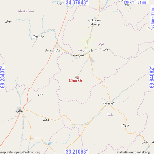
Charkh GPS coordinates[2]
33° 47' 49.632" North, 68° 56' 14.964" East
| Map corner | latitude | longitude |
|---|---|---|
| Upper-left | 34.37943°, | 68.23437° |
| Center: | 33.79712°, | 68.93749° |
| Lower-right: | 33.21083°, | 69.64062° |
| Map W x H: | 129.9×129.9 km | = 80.7×80.7mi |
| max Lat: | 38.4435° ⇑69.5% North |
| Charkh: | 33.79712° |
| min Lat: | ⇓30.5% South 30.15° |
| min Long | Charkh | max Long |
| 61.06667° | 68.93749° | 72.318° |
| W 57.6%⇐ | ⇒42.4% E |
Elevation
Elevation of Charkh is 2081 m = 6827 ft, and this is 662.6 m = 2174 ft above average elevation for this country.
| Max E: |
3068 m = 10066 ft | 22.8% |
| Charkh | 2081 m 6827 ft | |
| Avg. | 1418.4 m = 4654 ft | |
Min E: |
254 m = 833 ft | 77.2% |
See also: Afghanistan elevation on elevation.city.
Geographical zone
Charkh is located in North temperate zone (between Tropic of Cancer and the Arctic Circle). Distance of this Northern Tropic circle is 1152 km =715.8 mi to South.| Distance of | km | miles | from Charkh |
|---|---|---|---|
| North Pole | 6249.2 | 3883.1 | to North |
| Arctic Circle | 3643.3 | 2263.8 | to North |
| Tropic Cancer | 1152 | 715.8 | to South |
| Equator | 3757.9 | 2335.1 | to South |


Nearby cities:
15 places around Charkh: (largest is in red/bold)
• Baraki Barak
19 km =11.8 mi,  3°
3°
• Gardez
34.7 km =21.6 mi,  129°
129°
• Ghazni
54.9 km =34.1 mi,  240°
240°
• Kalān Deh
49.6 km =30.8 mi,  275°
275°
• Khōshī
34.1 km =21.2 mi,  48°
48°
• Markaz-e Sayyidābād
30.6 km =19 mi,  317°
317°
• Mutā Khān
62.3 km =38.7 mi,  186°
186°
• Muḩammad Āghah Wuluswālī
48.7 km =30.3 mi,  17°
17°
• Pul-e ‘Alam
23.4 km =14.5 mi, 19°
• Rāmak
42 km =26.1 mi,  223°
223°
• Salām Khēl
38.9 km =24.2 mi,  111°
111°
• Shwāk
58.1 km =36.1 mi,  135°
135°
• Tōrmay
51 km =31.7 mi,  256°
256°
• Wulêswālī Sayyid Karam
41.6 km =25.8 mi, 106°
• Zurmat
40.8 km =25.4 mi,  168°
168°
Sources, notices
• [Note1] Compared only with cities in Afghanistan existing in our database
• [Src1] Map data: © OpenStreetMap contributors (CC-BY-SA)
• [Src2] Other city data from geonames.org with taken over terms of usage.
• [Src3] Geographical zone / Annual Mean Temperature by Robert A. Rohde @ Wikipedia
