Khōshī geodata
Khōshī (Logar) is a seat of a second-order administrative division; located in Afghanistan in Asia/Kabul (GMT+4.5) time zone. In our database, there are 93 cities with bigger population. Compared to other cities in Afghanistan, 66.2% of cities are located further ↑North; 65.6% of cities are located further ←West and 85.5% of cities have lower elevation than Khōshī. Note1


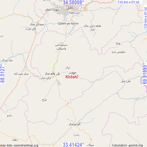
Khōshī GPS coordinates[2]
33° 59' 56.976" North, 69° 12' 56.952" East
| Map corner | latitude | longitude |
|---|---|---|
| Upper-left | 34.58008°, | 68.5127° |
| Center: | 33.99916°, | 69.21582° |
| Lower-right: | 33.41424°, | 69.91895° |
| Map W x H: | 129.6×129.6 km | = 80.5×80.5mi |
| max Lat: | 38.4435° ⇑66.2% North |
| Khōshī: | 33.99916° |
| min Lat: | ⇓33.8% South 30.15° |
| min Long | Khōshī | max Long |
| 61.06667° | 69.21582° | 72.318° |
| W 65.6%⇐ | ⇒34.4% E |
Elevation
Elevation of Khōshī is 2252 m = 7388 ft, and this is 833.6 m = 2735 ft above average elevation for this country.
| Max E: |
3068 m = 10066 ft | 14.5% |
| Khōshī | 2252 m 7388 ft | |
| Avg. | 1418.4 m = 4654 ft | |
Min E: |
254 m = 833 ft | 85.5% |
See also: Afghanistan elevation on elevation.city.
Geographical zone
Khōshī is located in North temperate zone (between Tropic of Cancer and the Arctic Circle). Distance of this Northern Tropic circle is 1174.4 km =729.7 mi to South.| Distance of | km | miles | from Khōshī |
|---|---|---|---|
| North Pole | 6226.7 | 3869.1 | to North |
| Arctic Circle | 3620.8 | 2249.9 | to North |
| Tropic Cancer | 1174.4 | 729.7 | to South |
| Equator | 3780.4 | 2349 | to South |


Nearby cities:
15 places around Khōshī: (largest is in red/bold)
• Bagrāmī
55.3 km =34.4 mi,  5°
5°
• Baraki Barak
24.8 km =15.4 mi,  261°
261°
• Chakaray
43.1 km =26.8 mi,  28°
28°
• Charkh
34.1 km =21.2 mi,  228°
228°
• Gardez
44.7 km =27.8 mi,  178°
178°
• Kabul
59 km =36.7 mi,  356°
356°
• Markaz-e Sayyidābād
46.3 km =28.8 mi,  270°
270°
• Maydanshakhr
54.6 km =33.9 mi,  323°
323°
• Muḩammad Āghah Wuluswālī
26.2 km =16.3 mi,  336°
336°
• Pul-e ‘Alam
17.8 km =11.1 mi, 268°
• Qal‘ah-ye Na‘īm
44.7 km =27.8 mi,  354°
354°
• Salām Khēl
38 km =23.6 mi,  163°
163°
• Wulêswālī Sayyid Karam
37.1 km =23.1 mi, 157°
• Ḩukūmatī Azrah
44.1 km =27.4 mi,  63°
63°
• ‘Alī Khēl
46.8 km =29.1 mi,  97°
97°
Sources, notices
• [Note1] Compared only with cities in Afghanistan existing in our database
• [Src1] Map data: © OpenStreetMap contributors (CC-BY-SA)
• [Src2] Other city data from geonames.org with taken over terms of usage.
• [Src3] Geographical zone / Annual Mean Temperature by Robert A. Rohde @ Wikipedia
