Aghavnadzor geodata
Aghavnadzor (Kotayk) is a populated place; located in Armenia in Asia/Yerevan (GMT+4) time zone. With population of 1,252 people, there are 257 cities with bigger population in this country. Compared to other cities in Armenia, 73.2% of cities are located further ↓South; 66.2% of cities are located further ←West and 79.9% of cities have lower elevation than Aghavnadzor. Note1


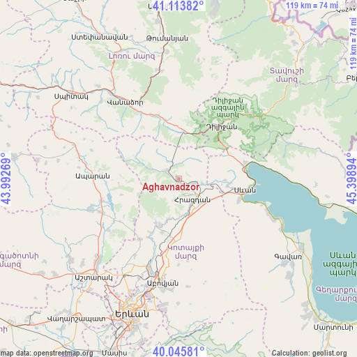
Aghavnadzor GPS coordinates[2]
40° 34' 55.02" North, 44° 41' 44.916" East
| Map corner | latitude | longitude |
|---|---|---|
| Upper-left | 41.11382°, | 43.99269° |
| Center: | 40.58195°, | 44.69581° |
| Lower-right: | 40.04581°, | 45.39894° |
| Map W x H: | 118.8×118.8 km | = 73.8×73.8mi |
| max Lat: | 41.24358° ⇑26.8% North |
| Aghavnadzor: | 40.58195° |
| min Lat: | ⇓73.2% South 38.90292° |
| min Long | Aghavnadzor | max Long |
| 43.74722° | 44.69581° | 46.5446° |
| W 66.2%⇐ | ⇒33.8% E |
Elevation
Elevation of Aghavnadzor is 1771 m = 5810 ft, and this is 469.5 m = 1540 ft above average elevation for this country.
| Max E: |
2169 m = 7116 ft | 20.1% |
| Aghavnadzor | 1771 m 5810 ft | |
| Avg. | 1301.5 m = 4270 ft | |
Min E: |
440 m = 1444 ft | 79.9% |
See also: Armenia elevation on elevation.city.
Geographical zone
Aghavnadzor is located in North temperate zone (between Tropic of Cancer and the Arctic Circle). Distance of this Northern Tropic circle is 1906.4 km =1184.6 mi to South.| Distance of | km | miles | from Aghavnadzor |
|---|---|---|---|
| North Pole | 5494.8 | 3414.3 | to North |
| Arctic Circle | 2888.9 | 1795.1 | to North |
| Tropic Cancer | 1906.4 | 1184.6 | to South |
| Equator | 4512.3 | 2803.8 | to South |


Nearby cities:
15 places around Aghavnadzor: (largest is in red/bold)
• Arzakan
16.4 km =10.2 mi,  206°
206°
• Bjni
14.3 km =8.9 mi,  195°
195°
• Buzhakan
20.5 km =12.7 mi,  226°
226°
• Ddmashen
10.8 km =6.7 mi,  96°
96°
• Fioletovo
15.7 km =9.8 mi,  6°
6°
• Gagarin
15.4 km =9.6 mi,  107°
107°
• Geghamavan
16.5 km =10.3 mi, 97°
• Hrazdan
11.1 km =6.9 mi,  147°
147°
• Lerrnanist
15.2 km =9.4 mi, 147°
• Margahovit
16.9 km =10.5 mi,  356°
356°
• Meghradzor
4.6 km =2.9 mi,  305°
305°
• Solak
13.3 km =8.3 mi,  175°
175°
• Tsaghkadzor
5.9 km =3.7 mi,  159°
159°
• Varser
18.2 km =11.3 mi, 99°
• Zovaber
8.2 km =5.1 mi, 101°
Sources, notices
• [Note1] Compared only with cities in Armenia existing in our database
• [Src1] Map data: © OpenStreetMap contributors (CC-BY-SA)
• [Src2] Other city data from geonames.org with taken over terms of usage.
• [Src3] Geographical zone / Annual Mean Temperature by Robert A. Rohde @ Wikipedia
