Arteni geodata
Arteni (Aragatsotn) is a populated place; located in Armenia in Asia/Yerevan (GMT+4) time zone. With population of 3,086 people, there are 88 cities with bigger population in this country. Compared to other cities in Armenia, 58% of cities are located further ↓South; 99.4% of cities are located further →East and 53.8% of cities have higher elevation than Arteni. Note1


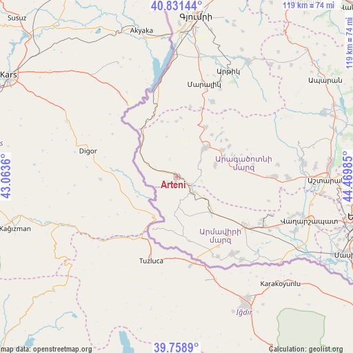
Arteni GPS coordinates[2]
40° 17' 50.28" North, 43° 46' 0.192" East
| Map corner | latitude | longitude |
|---|---|---|
| Upper-left | 40.83144°, | 43.0636° |
| Center: | 40.2973°, | 43.76672° |
| Lower-right: | 39.7589°, | 44.46985° |
| Map W x H: | 119.3×119.3 km | = 74.1×74.1mi |
| max Lat: | 41.24358° ⇑42% North |
| Arteni: | 40.2973° |
| min Lat: | ⇓58% South 38.90292° |
| min Long | Arteni | max Long |
| 43.74722° | 43.76672° | 46.5446° |
| W 0.6%⇐ | ⇒99.4% E |
Elevation
Elevation of Arteni is 1206 m = 3957 ft, and this is 95.5 m = 313 ft below average elevation for this country.
| Max E: |
2169 m = 7116 ft | 53.8% |
| Avg. | 1301.5 m = 4270 ft | |
| Arteni | 1206 m = 3957 ft | |
Min E: |
440 m = 1444 ft | 46.2% |
See also: Armenia elevation on elevation.city.
Geographical zone
Arteni is located in North temperate zone (between Tropic of Cancer and the Arctic Circle). Distance of this Northern Tropic circle is 1874.7 km =1164.9 mi to South.| Distance of | km | miles | from Arteni |
|---|---|---|---|
| North Pole | 5526.4 | 3433.9 | to North |
| Arctic Circle | 2920.5 | 1814.7 | to North |
| Tropic Cancer | 1874.7 | 1164.9 | to South |
| Equator | 4480.6 | 2784.1 | to South |


Nearby cities:
15 places around Arteni: (largest is in red/bold)
• Agarakavan
26.2 km =16.3 mi,  81°
81°
• Armavir
28 km =17.4 mi,  124°
124°
• Ashnak
13.2 km =8.2 mi,  73°
73°
• Bambakashat
30 km =18.6 mi,  134°
134°
• Dalarik
12.2 km =7.6 mi, 129°
• Dzit’hank’ov
23.9 km =14.9 mi,  11°
11°
• Getashen
31.8 km =19.8 mi,  152°
152°
• Lenughi
25.4 km =15.8 mi,  138°
138°
• Lukashin
23.6 km =14.7 mi, 121°
• Mayisyan
31.7 km =19.7 mi, 119°
• Myasnikyan
18.4 km =11.4 mi, 135°
• Nor Armavir
30.4 km =18.9 mi, 140°
• Sardarapat
27.6 km =17.1 mi, 131°
• Shenavan
30.3 km =18.8 mi, 152°
• T’alin
14.1 km =8.8 mi,  41°
41°
Sources, notices
• [Note1] Compared only with cities in Armenia existing in our database
• [Src1] Map data: © OpenStreetMap contributors (CC-BY-SA)
• [Src2] Other city data from geonames.org with taken over terms of usage.
• [Src3] Geographical zone / Annual Mean Temperature by Robert A. Rohde @ Wikipedia
