Famatina geodata
Famatina (La Rioja) is a seat of a second-order administrative division; located in Argentina in America/Argentina/La_Rioja (GMT-3) time zone. In our database, there are 785 cities with bigger population. Compared to other cities in Argentina, 69.1% of cities are located further ↓South; 87.8% of cities are located further →East and 97.2% of cities have lower elevation than Famatina. Note1


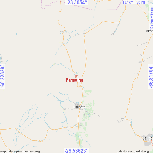
Famatina GPS coordinates[2]
28° 55' 21.504" South, 67° 31' 12.576" West
| Map corner | latitude | longitude |
|---|---|---|
| Upper-left | -28.3054°, | -68.22329° |
| Center: | -28.92264°, | -67.52016° |
| Lower-right: | -29.53623°, | -66.81704° |
| Map W x H: | 136.9×136.9 km | = 85.1×85.1mi |
| max Lat: | -21.94467° ⇑30.9% North |
| Famatina: | -28.92264° |
| min Lat: | ⇓69.1% South -54.81084° |
| min Long | Famatina | max Long |
| -72.88605° | -67.52016° | -53.64581° |
| W 12.2%⇐ | ⇒87.8% E |
Elevation
Elevation of Famatina is 1567 m = 5141 ft, and this is 1217.7 m = 3995 ft above average elevation for this country.
| Max E: |
4040 m = 13255 ft | 2.8% |
| Famatina | 1567 m 5141 ft | |
| Avg. | 349.3 m = 1146 ft | |
Min E: |
-2 m = -7 ft | 97.2% |
See also: Argentina elevation on elevation.city.
Geographical zone
Famatina is located in South temperate zone (between Tropic of Capricorn and the Antarctic Circle). Distance of this Southern Tropic circle is 610 km =379 mi to North.| Distance of | km | miles | from Famatina |
|---|---|---|---|
| Equator | 3215.9 | 1998.3 | to North |
| Tropic Capricorn | 610 | 379 | to North |
| Antarctic Circle | 4185.3 | 2600.6 | to South |
| South Pole | 6791.2 | 4219.9 | to South |


Nearby cities:
15 places around Famatina: (largest is in red/bold)
• Aimogasta
80.4 km =50 mi,  59°
59°
• Aminga
58 km =36 mi,  81°
81°
• Arauco
80.5 km =50 mi, 61°
• Chilecito
26.7 km =16.6 mi,  175°
175°
• Chumbicha
125.3 km =77.9 mi,  86°
86°
• Fiambalá
139.4 km =86.6 mi,  356°
356°
• La Rioja
84.7 km =52.6 mi,  129°
129°
• Patquía
139.4 km =86.6 mi,  153°
153°
• San Blas de los Sauces
70.5 km =43.8 mi,  36°
36°
• Sañogasta
43.7 km =27.2 mi,  116°
116°
• Tinogasta
95.7 km =59.5 mi, 357°
• Villa Bustos
63.2 km =39.3 mi, 129°
• Villa Castelli
69.2 km =43 mi,  261°
261°
• Villa Unión
81.4 km =50.6 mi,  237°
237°
• Vinchina
69.3 km =43.1 mi,  285°
285°
Sources, notices
• [Note1] Compared only with cities in Argentina existing in our database
• [Src1] Map data: © OpenStreetMap contributors (CC-BY-SA)
• [Src2] Other city data from geonames.org with taken over terms of usage.
• [Src3] Geographical zone / Annual Mean Temperature by Robert A. Rohde @ Wikipedia
