Arauco geodata
Arauco (La Rioja) is a populated place; located in Argentina in America/Argentina/La_Rioja (GMT-3) time zone. With population of 13,720 people, there are 242 cities with bigger population in this country. Compared to other cities in Argentina, 70.6% of cities are located further ↓South; 85% of cities are located further →East and 88.9% of cities have lower elevation than Arauco. Note1


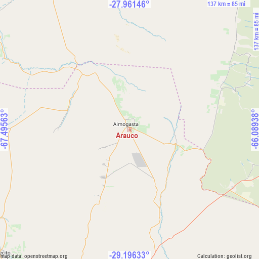
Arauco GPS coordinates[2]
28° 34' 50.556" South, 66° 47' 33" West
| Map corner | latitude | longitude |
|---|---|---|
| Upper-left | -27.96146°, | -67.49563° |
| Center: | -28.58071°, | -66.7925° |
| Lower-right: | -29.19633°, | -66.08938° |
| Map W x H: | 137.3×137.3 km | = 85.3×85.3mi |
| max Lat: | -21.94467° ⇑29.4% North |
| Arauco: | -28.58071° |
| min Lat: | ⇓70.6% South -54.81084° |
| min Long | Arauco | max Long |
| -72.88605° | -66.7925° | -53.64581° |
| W 15%⇐ | ⇒85% E |
Elevation
Elevation of Arauco is 820 m = 2690 ft, and this is 470.7 m = 1544 ft above average elevation for this country.
| Max E: |
4040 m = 13255 ft | 11.1% |
| Arauco | 820 m 2690 ft | |
| Avg. | 349.3 m = 1146 ft | |
Min E: |
-2 m = -7 ft | 88.9% |
See also: Argentina elevation on elevation.city.
Geographical zone
Arauco is located in South temperate zone (between Tropic of Capricorn and the Antarctic Circle). Distance of this Southern Tropic circle is 572 km =355.4 mi to North.| Distance of | km | miles | from Arauco |
|---|---|---|---|
| Equator | 3177.9 | 1974.7 | to North |
| Tropic Capricorn | 572 | 355.4 | to North |
| Antarctic Circle | 4223.3 | 2624.2 | to South |
| South Pole | 6829.2 | 4243.5 | to South |


Nearby cities:
15 places around Arauco: (largest is in red/bold)
• Aimogasta
2.6 km =1.6 mi,  329°
329°
• Aminga
32.6 km =20.3 mi,  204°
204°
• Capayán
75.8 km =47.1 mi,  106°
106°
• Chilecito
94.3 km =58.6 mi,  226°
226°
• Chumbicha
62.3 km =38.7 mi,  119°
119°
• Famatina
80.5 km =50 mi,  241°
241°
• Huillapima
81 km =50.3 mi,  101°
101°
• La Rioja
92.5 km =57.5 mi,  183°
183°
• Mutquín
69.8 km =43.4 mi,  65°
65°
• Pomán
59.6 km =37 mi, 69°
• San Blas de los Sauces
35 km =21.7 mi,  302°
302°
• Saujil
72.6 km =45.1 mi,  51°
51°
• Sañogasta
65.3 km =40.6 mi,  208°
208°
• Tinogasta
95 km =59 mi,  307°
307°
• Villa Bustos
81.5 km =50.6 mi, 195°
Sources, notices
• [Note1] Compared only with cities in Argentina existing in our database
• [Src1] Map data: © OpenStreetMap contributors (CC-BY-SA)
• [Src2] Other city data from geonames.org with taken over terms of usage.
• [Src3] Geographical zone / Annual Mean Temperature by Robert A. Rohde @ Wikipedia
