Aimogasta geodata
Aimogasta (La Rioja) is a seat of a second-order administrative division; located in Argentina in America/Argentina/La_Rioja (GMT-3) time zone. In our database, there are 785 cities with bigger population. Compared to other cities in Argentina, 70.8% of cities are located further ↓South; 85.1% of cities are located further →East and 89.3% of cities have lower elevation than Aimogasta. Note1


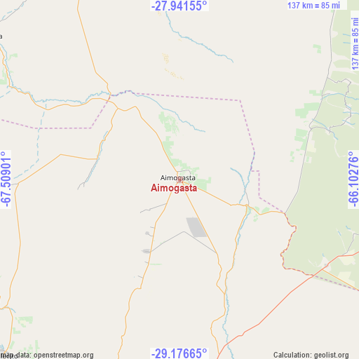
Aimogasta GPS coordinates[2]
28° 33' 39.276" South, 66° 48' 21.168" West
| Map corner | latitude | longitude |
|---|---|---|
| Upper-left | -27.94155°, | -67.50901° |
| Center: | -28.56091°, | -66.80588° |
| Lower-right: | -29.17665°, | -66.10276° |
| Map W x H: | 137.3×137.3 km | = 85.3×85.3mi |
| max Lat: | -21.94467° ⇑29.2% North |
| Aimogasta: | -28.56091° |
| min Lat: | ⇓70.8% South -54.81084° |
| min Long | Aimogasta | max Long |
| -72.88605° | -66.80588° | -53.64581° |
| W 14.9%⇐ | ⇒85.1% E |
Elevation
Elevation of Aimogasta is 846 m = 2776 ft, and this is 496.7 m = 1630 ft above average elevation for this country.
| Max E: |
4040 m = 13255 ft | 10.7% |
| Aimogasta | 846 m 2776 ft | |
| Avg. | 349.3 m = 1146 ft | |
Min E: |
-2 m = -7 ft | 89.3% |
See also: Argentina elevation on elevation.city.
Geographical zone
Aimogasta is located in South temperate zone (between Tropic of Capricorn and the Antarctic Circle). Distance of this Southern Tropic circle is 569.8 km =354.1 mi to North.| Distance of | km | miles | from Aimogasta |
|---|---|---|---|
| Equator | 3175.7 | 1973.3 | to North |
| Tropic Capricorn | 569.8 | 354.1 | to North |
| Antarctic Circle | 4225.5 | 2625.6 | to South |
| South Pole | 6831.4 | 4244.8 | to South |


Nearby cities:
15 places around Aimogasta: (largest is in red/bold)
• Aminga
34.1 km =21.2 mi,  200°
200°
• Arauco
2.6 km =1.6 mi,  149°
149°
• Capayán
77.7 km =48.3 mi,  107°
107°
• Chilecito
94.9 km =59 mi,  225°
225°
• Chumbicha
64.5 km =40.1 mi,  120°
120°
• Famatina
80.4 km =50 mi,  239°
239°
• Huillapima
82.8 km =51.4 mi,  102°
102°
• La Rioja
94.6 km =58.8 mi,  182°
182°
• Mutquín
70.1 km =43.6 mi,  67°
67°
• Pomán
60.1 km =37.3 mi, 72°
• San Blas de los Sauces
32.7 km =20.3 mi,  300°
300°
• Saujil
72.3 km =44.9 mi,  53°
53°
• Sañogasta
66.6 km =41.4 mi,  206°
206°
• Tinogasta
92.6 km =57.5 mi,  306°
306°
• Villa Bustos
83.3 km =51.8 mi,  194°
194°
Sources, notices
• [Note1] Compared only with cities in Argentina existing in our database
• [Src1] Map data: © OpenStreetMap contributors (CC-BY-SA)
• [Src2] Other city data from geonames.org with taken over terms of usage.
• [Src3] Geographical zone / Annual Mean Temperature by Robert A. Rohde @ Wikipedia
