Pierbach geodata
Pierbach (Upper Austria) is a seat of a third-order administrative division; located in Austria in Europe/Vienna (GMT+2) time zone. With population of 274 people, there are 2778 cities with bigger population in this country. Compared to other cities in Austria, 88.3% of cities are located further ↓South; 50.6% of cities are located further ←West and 56.7% of cities have lower elevation than Pierbach. Note1
Administrative division(s):
- Level 1: Upper Austria
- Level 2: Politischer Bezirk Freistadt
- Level 3: Pierbach


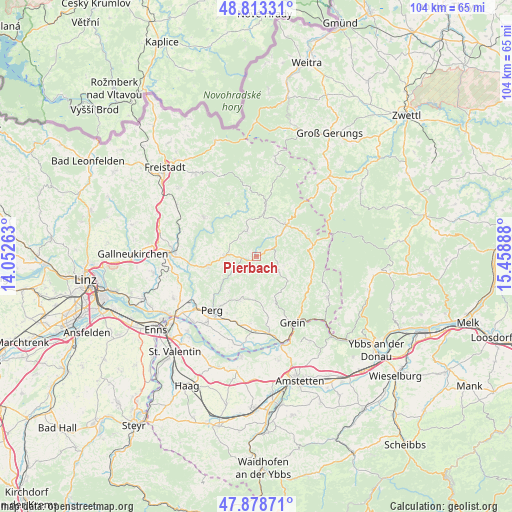
Pierbach GPS coordinates[2]
48° 20' 53.34" North, 14° 45' 20.7" East
| Map corner | latitude | longitude |
|---|---|---|
| Upper-left | 48.81331°, | 14.05263° |
| Center: | 48.34815°, | 14.75575° |
| Lower-right: | 47.87871°, | 15.45888° |
| Map W x H: | 103.9×103.9 km | = 64.6×64.6mi |
| max Lat: | 48.98333° ⇑11.7% North |
| Pierbach: | 48.34815° |
| min Lat: | ⇓88.3% South 46.48841° |
| min Long | Pierbach | max Long |
| 9.57802° | 14.75575° | 17.1° |
| W 50.6%⇐ | ⇒49.4% E |
Elevation
Elevation of Pierbach is 495 m = 1624 ft, and this is 10.5 m = 34 ft below average elevation for this country.
| Max E: |
2140 m = 7021 ft | 43.3% |
| Avg. | 505.5 m = 1658 ft | |
| Pierbach | 495 m = 1624 ft | |
Min E: |
118 m = 387 ft | 56.7% |
See also: Austria elevation on elevation.city.
Geographical zone
Pierbach is located in North temperate zone (between Tropic of Cancer and the Arctic Circle). Distance of this North polar circle is 2025.4 km =1258.5 mi to North.| Distance of | km | miles | from Pierbach |
|---|---|---|---|
| North Pole | 4631.3 | 2877.8 | to North |
| Arctic Circle | 2025.4 | 1258.5 | to North |
| Tropic Cancer | 2769.9 | 1721.1 | to South |
| Equator | 5375.8 | 3340.4 | to South |


Nearby cities:
15 places around Pierbach: (largest is in red/bold)
• Allerheiligen im Mühlkreis
9.3 km =5.8 mi,  236°
236°
• Arbing
13.8 km =8.6 mi,  196°
196°
• Bad Kreuzen
9.7 km =6 mi,  157°
157°
• Bad Zell
6.4 km =4 mi,  270°
270°
• Gutau
13.1 km =8.1 mi,  306°
306°
• Königswiesen
8.7 km =5.4 mi,  44°
44°
• Mönchdorf
3.2 km =2 mi,  64°
64°
• Münzbach
9.6 km =6 mi, 200°
• Pabneukirchen
5.3 km =3.3 mi,  120°
120°
• Sankt Georgen am Walde
10.9 km =6.8 mi,  83°
83°
• Sankt Leonhard bei Freistadt
12.1 km =7.5 mi,  331°
331°
• Schönau im Mühlkreis
5.5 km =3.4 mi,  339°
339°
• Tragwein
10 km =6.2 mi,  260°
260°
• Unterweissenbach
9.9 km =6.2 mi,  11°
11°
• Windhaag bei Perg
8.9 km =5.5 mi,  218°
218°
Sources, notices
• [Note1] Compared only with cities in Austria existing in our database
• [Src1] Map data: © OpenStreetMap contributors (CC-BY-SA)
• [Src2] Other city data from geonames.org with taken over terms of usage.
• [Src3] Geographical zone / Annual Mean Temperature by Robert A. Rohde @ Wikipedia
