Cossack geodata
Cossack (Northern Territory) is a section of populated place; located in Australia in Australia/Darwin (GMT+9.5) time zone. With population of 1,671 people, there are 3122 cities with bigger population in this country. Compared to other cities in Australia, 98.2% of cities are located further ↓South; 87.1% of cities are located further →East and 74.9% of cities have lower elevation than Cossack. Note1


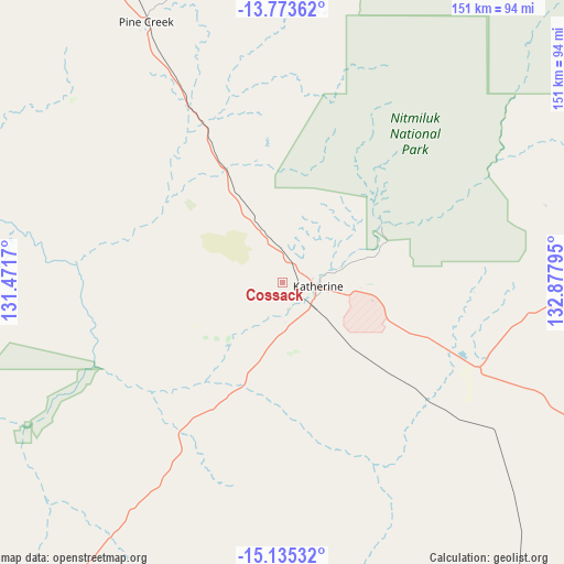
Cossack GPS coordinates[2]
14° 27' 19.836" South, 132° 10' 29.352" East
| Map corner | latitude | longitude |
|---|---|---|
| Upper-left | -13.77362°, | 131.4717° |
| Center: | -14.45551°, | 132.17482° |
| Lower-right: | -15.13532°, | 132.87795° |
| Map W x H: | 151.4×151.4 km | = 94.1×94.1mi |
| max Lat: | -10.58257° ⇑1.8% North |
| Cossack: | -14.45551° |
| min Lat: | ⇓98.2% South -43.31423° |
| min Long | Cossack | max Long |
| 113.53327° | 132.17482° | 153.61246° |
| W 12.9%⇐ | ⇒87.1% E |
Elevation
Elevation of Cossack is 131 m = 430 ft, and this is 9 m = 30 ft above average elevation for this country.
| Max E: |
1715 m = 5627 ft | 25.1% |
| Cossack | 131 m 430 ft | |
| Avg. | 122 m = 400 ft | |
Min E: |
-2 m = -7 ft | 74.9% |
See also: Australia elevation on elevation.city.
Geographical zone
Cossack is located in South Torrid zone (between Equator and Tropic of Capricorn). Distance of this Southern Tropic circle is 998.6 km =620.5 mi to South.| Distance of | km | miles | from Cossack |
|---|---|---|---|
| Equator | 1607.3 | 998.7 | to North |
| Tropic Capricorn | 998.6 | 620.5 | to South |
| Antarctic Circle | 5793.9 | 3600.2 | to South |
| South Pole | 8399.8 | 5219.4 | to South |


Nearby cities:
15 places around Cossack: (largest is in red/bold)
• Acacia Hills
216.8 km =134.7 mi,  328°
328°
• Batchelor
199.2 km =123.8 mi,  321°
321°
• Beswick
101.9 km =63.3 mi,  96°
96°
• Darwin River
223.7 km =139 mi, 324°
• Douglas-Daly
114.9 km =71.4 mi,  309°
309°
• Jabiru
211 km =131.1 mi,  19°
19°
• Kakadu
179.4 km =111.5 mi,  10°
10°
• Katherine
9.6 km =6 mi, 96°
• Katherine East
12 km =7.5 mi, 95°
• Katherine South
9.1 km =5.7 mi, 98°
• Lansdowne
23.1 km =14.4 mi,  83°
83°
• Marrakai
203.9 km =126.7 mi,  338°
338°
• Mataranka
108.9 km =67.7 mi,  118°
118°
• Miniyeri
221.9 km =137.9 mi,  112°
112°
• Tindal
23.6 km =14.7 mi, 110°
Sources, notices
• [Note1] Compared only with cities in Australia existing in our database
• [Src1] Map data: © OpenStreetMap contributors (CC-BY-SA)
• [Src2] Other city data from geonames.org with taken over terms of usage.
• [Src3] Geographical zone / Annual Mean Temperature by Robert A. Rohde @ Wikipedia
