Cleve geodata
Cleve (South Australia) is a populated place; located in Australia in Australia/Adelaide (GMT+10.5) time zone. With population of 1,142 people, there are 3650 cities with bigger population in this country. Compared to other cities in Australia, 51.3% of cities are located further ↓South; 86% of cities are located further →East and 81.4% of cities have lower elevation than Cleve. Note1


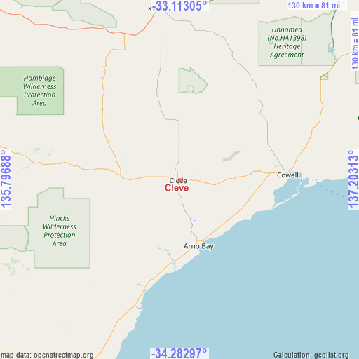
Cleve GPS coordinates[2]
33° 42' 0" South, 136° 30' 0" East
| Map corner | latitude | longitude |
|---|---|---|
| Upper-left | -33.11305°, | 135.79688° |
| Center: | -33.7°, | 136.5° |
| Lower-right: | -34.28297°, | 137.20313° |
| Map W x H: | 130.1×130.1 km | = 80.8×80.8mi |
| max Lat: | -10.58257° ⇑48.7% North |
| Cleve: | -33.7° |
| min Lat: | ⇓51.3% South -43.31423° |
| min Long | Cleve | max Long |
| 113.53327° | 136.5° | 153.61246° |
| W 14%⇐ | ⇒86% E |
Elevation
Elevation of Cleve is 196 m = 643 ft, and this is 74 m = 243 ft above average elevation for this country.
| Max E: |
1715 m = 5627 ft | 18.6% |
| Cleve | 196 m 643 ft | |
| Avg. | 122 m = 400 ft | |
Min E: |
-2 m = -7 ft | 81.4% |
See also: Australia elevation on elevation.city.
Geographical zone
Cleve is located in South temperate zone (between Tropic of Capricorn and the Antarctic Circle). Distance of this Southern Tropic circle is 1141.2 km =709.1 mi to North.| Distance of | km | miles | from Cleve |
|---|---|---|---|
| Equator | 3747.1 | 2328.3 | to North |
| Tropic Capricorn | 1141.2 | 709.1 | to North |
| Antarctic Circle | 3654.1 | 2270.6 | to South |
| South Pole | 6260 | 3889.8 | to South |


Nearby cities:
15 places around Cleve: (largest is in red/bold)
• Arno Bay
23.1 km =14.4 mi,  164°
164°
• Cowell
39 km =24.2 mi,  87°
87°
• Cummins
95 km =59 mi,  228°
228°
• Kadina
116.1 km =72.1 mi,  104°
104°
• Kimba
62.5 km =38.8 mi,  353°
353°
• Moonta
108.7 km =67.5 mi,  112°
112°
• Moonta Bay
105.9 km =65.8 mi, 111°
• North Moonta
108.3 km =67.3 mi, 111°
• Port Hughes
105.9 km =65.8 mi, 113°
• Tumby Bay
83.8 km =52.1 mi,  206°
206°
• Wallaroo
108 km =67.1 mi, 104°
• Whyalla Jenkins
120.5 km =74.9 mi,  51°
51°
• Whyalla Norrie
122 km =75.8 mi, 52°
• Whyalla Stuart
121.2 km =75.3 mi, 51°
• Wudinna
120.3 km =74.8 mi,  306°
306°
Sources, notices
• [Note1] Compared only with cities in Australia existing in our database
• [Src1] Map data: © OpenStreetMap contributors (CC-BY-SA)
• [Src2] Other city data from geonames.org with taken over terms of usage.
• [Src3] Geographical zone / Annual Mean Temperature by Robert A. Rohde @ Wikipedia
