Arno Bay geodata
Arno Bay (South Australia) is a populated place; located in Australia in Australia/Adelaide (GMT+10.5) time zone. With population of 504 people, there are 4868 cities with bigger population in this country. Compared to other cities in Australia, 56.1% of cities are located further ↑North; 86% of cities are located further →East and 76.1% of cities have higher elevation than Arno Bay. Note1


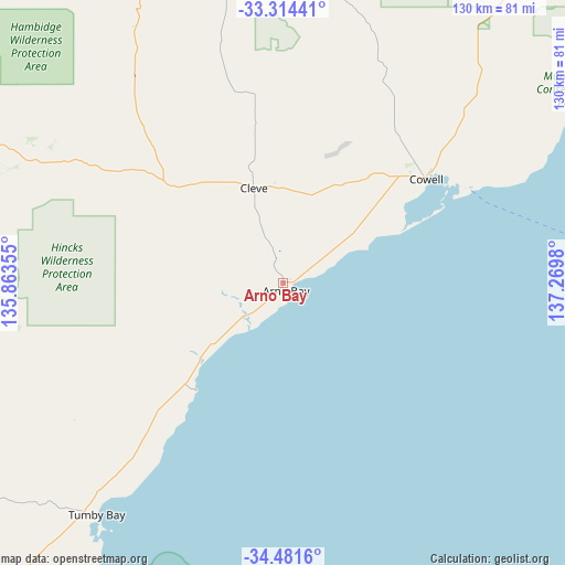
Arno Bay GPS coordinates[2]
33° 54' 0" South, 136° 34' 0.012" East
| Map corner | latitude | longitude |
|---|---|---|
| Upper-left | -33.31441°, | 135.86355° |
| Center: | -33.9°, | 136.56667° |
| Lower-right: | -34.4816°, | 137.2698° |
| Map W x H: | 129.8×129.8 km | = 80.7×80.7mi |
| max Lat: | -10.58257° ⇑56.1% North |
| Arno Bay: | -33.9° |
| min Lat: | ⇓43.9% South -43.31423° |
| min Long | Arno Bay | max Long |
| 113.53327° | 136.56667° | 153.61246° |
| W 14%⇐ | ⇒86% E |
Elevation
Elevation of Arno Bay is 18 m = 59 ft, and this is 104 m = 341 ft below average elevation for this country.
| Max E: |
1715 m = 5627 ft | 76.1% |
| Avg. | 122 m = 400 ft | |
| Arno Bay | 18 m = 59 ft | |
Min E: |
-2 m = -7 ft | 23.9% |
See also: Australia elevation on elevation.city.
Geographical zone
Arno Bay is located in South temperate zone (between Tropic of Capricorn and the Antarctic Circle). Distance of this Southern Tropic circle is 1163.4 km =722.9 mi to North.| Distance of | km | miles | from Arno Bay |
|---|---|---|---|
| Equator | 3769.3 | 2342.1 | to North |
| Tropic Capricorn | 1163.4 | 722.9 | to North |
| Antarctic Circle | 3631.8 | 2256.7 | to South |
| South Pole | 6237.7 | 3875.9 | to South |


Nearby cities:
15 places around Arno Bay: (largest is in red/bold)
• Cleve
23.1 km =14.4 mi,  344°
344°
• Cowell
40.7 km =25.3 mi,  53°
53°
• Cummins
87.4 km =54.3 mi,  242°
242°
• Kadina
106.3 km =66.1 mi,  93°
93°
• Kimba
85.4 km =53.1 mi,  350°
350°
• Maitland
114.7 km =71.3 mi,  117°
117°
• Moonta
96.3 km =59.8 mi,  101°
101°
• Moonta Bay
93.7 km =58.2 mi, 100°
• North Moonta
96.2 km =59.8 mi, 100°
• Port Broughton
130.9 km =81.3 mi,  75°
75°
• Port Hughes
92.9 km =57.7 mi, 102°
• Port Lincoln
111.7 km =69.4 mi,  214°
214°
• Tumby Bay
68.2 km =42.4 mi,  218°
218°
• Wallaroo
98.5 km =61.2 mi, 92°
• Whyalla Jenkins
131.3 km =81.6 mi,  41°
41°
Sources, notices
• [Note1] Compared only with cities in Australia existing in our database
• [Src1] Map data: © OpenStreetMap contributors (CC-BY-SA)
• [Src2] Other city data from geonames.org with taken over terms of usage.
• [Src3] Geographical zone / Annual Mean Temperature by Robert A. Rohde @ Wikipedia
