Tumby Bay geodata
Tumby Bay (South Australia) is a populated place; located in Australia in Australia/Adelaide (GMT+10.5) time zone. With population of 1,696 people, there are 3106 cities with bigger population in this country. Compared to other cities in Australia, 62.2% of cities are located further ↑North; 86.1% of cities are located further →East and 91.8% of cities have higher elevation than Tumby Bay. Note1


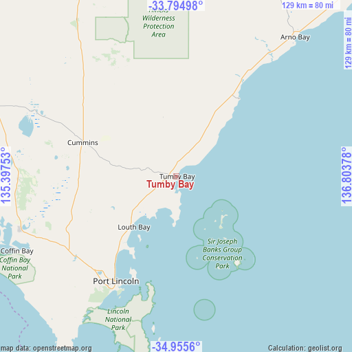
Tumby Bay GPS coordinates[2]
34° 22' 38.28" South, 136° 6' 2.34" East
| Map corner | latitude | longitude |
|---|---|---|
| Upper-left | -33.79498°, | 135.39753° |
| Center: | -34.3773°, | 136.10065° |
| Lower-right: | -34.9556°, | 136.80378° |
| Map W x H: | 129×129 km | = 80.2×80.2mi |
| max Lat: | -10.58257° ⇑62.2% North |
| Tumby Bay: | -34.3773° |
| min Lat: | ⇓37.8% South -43.31423° |
| min Long | Tumby Bay | max Long |
| 113.53327° | 136.10065° | 153.61246° |
| W 13.9%⇐ | ⇒86.1% E |
Elevation
Elevation of Tumby Bay is 8 m = 26 ft, and this is 114 m = 374 ft below average elevation for this country.
| Max E: |
1715 m = 5627 ft | 91.8% |
| Avg. | 122 m = 400 ft | |
| Tumby Bay | 8 m = 26 ft | |
Min E: |
-2 m = -7 ft | 8.2% |
See also: Australia elevation on elevation.city.
Geographical zone
Tumby Bay is located in South temperate zone (between Tropic of Capricorn and the Antarctic Circle). Distance of this Southern Tropic circle is 1216.5 km =755.9 mi to North.| Distance of | km | miles | from Tumby Bay |
|---|---|---|---|
| Equator | 3822.4 | 2375.1 | to North |
| Tropic Capricorn | 1216.5 | 755.9 | to North |
| Antarctic Circle | 3578.8 | 2223.8 | to South |
| South Pole | 6184.7 | 3843 | to South |


Nearby cities:
15 places around Tumby Bay: (largest is in red/bold)
• Arno Bay
68.2 km =42.4 mi,  38°
38°
• Cleve
83.8 km =52.1 mi,  26°
26°
• Coffin Bay
75 km =46.6 mi,  252°
252°
• Cowell
108.1 km =67.2 mi, 44°
• Cummins
36.6 km =22.7 mi,  290°
290°
• Kimba
140.5 km =87.3 mi,  12°
12°
• Maitland
144.3 km =89.7 mi,  89°
89°
• Minlaton
143.7 km =89.3 mi,  107°
107°
• Moonta
141.2 km =87.7 mi,  75°
75°
• Moonta Bay
139.6 km =86.7 mi,  74°
74°
• North Moonta
141.9 km =88.2 mi, 75°
• Port Hughes
137.2 km =85.3 mi, 76°
• Port Lincoln
44 km =27.3 mi,  208°
208°
• Wallaroo
149.2 km =92.7 mi, 70°
• Yorketown
154.9 km =96.3 mi,  117°
117°
Sources, notices
• [Note1] Compared only with cities in Australia existing in our database
• [Src1] Map data: © OpenStreetMap contributors (CC-BY-SA)
• [Src2] Other city data from geonames.org with taken over terms of usage.
• [Src3] Geographical zone / Annual Mean Temperature by Robert A. Rohde @ Wikipedia
