Broome geodata
Broome (Western Australia) is a populated place; located in Australia in Australia/Perth (GMT+8) time zone. With population of 5,314 people, there are 1398 cities with bigger population in this country. Compared to other cities in Australia, 96.1% of cities are located further ↓South; 88.8% of cities are located further →East and 85% of cities have higher elevation than Broome. Note1


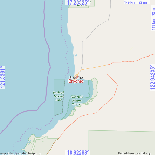
Broome GPS coordinates[2]
17° 57' 19.368" South, 122° 14' 21.192" East
| Map corner | latitude | longitude |
|---|---|---|
| Upper-left | -17.28525°, | 121.5361° |
| Center: | -17.95538°, | 122.23922° |
| Lower-right: | -18.62298°, | 122.94235° |
| Map W x H: | 148.7×148.7 km | = 92.4×92.4mi |
| max Lat: | -10.58257° ⇑3.9% North |
| Broome: | -17.95538° |
| min Lat: | ⇓96.1% South -43.31423° |
| min Long | Broome | max Long |
| 113.53327° | 122.23922° | 153.61246° |
| W 11.2%⇐ | ⇒88.8% E |
Elevation
Elevation of Broome is 12 m = 39 ft, and this is 110 m = 361 ft below average elevation for this country.
| Max E: |
1715 m = 5627 ft | 85% |
| Avg. | 122 m = 400 ft | |
| Broome | 12 m = 39 ft | |
Min E: |
-2 m = -7 ft | 15% |
See also: Australia elevation on elevation.city.
Geographical zone
Broome is located in South Torrid zone (between Equator and Tropic of Capricorn). Distance of this Southern Tropic circle is 609.5 km =378.7 mi to South.| Distance of | km | miles | from Broome |
|---|---|---|---|
| Equator | 1996.5 | 1240.6 | to North |
| Tropic Capricorn | 609.5 | 378.7 | to South |
| Antarctic Circle | 5404.7 | 3358.3 | to South |
| South Pole | 8010.6 | 4977.6 | to South |


Nearby cities:
13 places around Broome: (largest is in red/bold)
• Bilingurr
5.3 km =3.3 mi,  348°
348°
• Cable Beach
2.9 km =1.8 mi,  257°
257°
• Camballin
206.4 km =128.3 mi,  91°
91°
• Dampier Peninsula
131.7 km =81.8 mi,  30°
30°
• Derby
164.1 km =102 mi,  63°
63°
• Djugun
1.2 km =0.7 mi,  277°
277°
• Eighty Mile Beach
157.4 km =97.8 mi,  204°
204°
• Fitzroy Crossing
352.7 km =219.2 mi, 94°
• King Leopold Ranges
356.3 km =221.4 mi,  74°
74°
• Lagrange
94 km =58.4 mi,  210°
210°
• Roebuck
36.6 km =22.7 mi,  130°
130°
• St George Ranges
313.6 km =194.9 mi,  111°
111°
• Telfer
377.6 km =234.6 mi,  163°
163°
Sources, notices
• [Note1] Compared only with cities in Australia existing in our database
• [Src1] Map data: © OpenStreetMap contributors (CC-BY-SA)
• [Src2] Other city data from geonames.org with taken over terms of usage.
• [Src3] Geographical zone / Annual Mean Temperature by Robert A. Rohde @ Wikipedia
