Camballin geodata
Camballin (Western Australia) is a populated place; located in Australia in Australia/Perth (GMT+8) time zone. With population of 738 people, there are 4264 cities with bigger population in this country. Compared to other cities in Australia, 96.1% of cities are located further ↓South; 88.7% of cities are located further →East and 53.1% of cities have higher elevation than Camballin. Note1


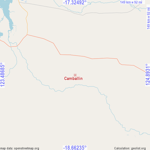
Camballin GPS coordinates[2]
17° 59' 41.64" South, 124° 11' 23.892" East
| Map corner | latitude | longitude |
|---|---|---|
| Upper-left | -17.32492°, | 123.48685° |
| Center: | -17.9949°, | 124.18997° |
| Lower-right: | -18.66235°, | 124.8931° |
| Map W x H: | 148.7×148.7 km | = 92.4×92.4mi |
| max Lat: | -10.58257° ⇑3.9% North |
| Camballin: | -17.9949° |
| min Lat: | ⇓96.1% South -43.31423° |
| min Long | Camballin | max Long |
| 113.53327° | 124.18997° | 153.61246° |
| W 11.3%⇐ | ⇒88.7% E |
Elevation
Elevation of Camballin is 41 m = 135 ft, and this is 81 m = 266 ft below average elevation for this country.
| Max E: |
1715 m = 5627 ft | 53.1% |
| Avg. | 122 m = 400 ft | |
| Camballin | 41 m = 135 ft | |
Min E: |
-2 m = -7 ft | 46.9% |
See also: Australia elevation on elevation.city.
Geographical zone
Camballin is located in South Torrid zone (between Equator and Tropic of Capricorn). Distance of this Southern Tropic circle is 605.1 km =376 mi to South.| Distance of | km | miles | from Camballin |
|---|---|---|---|
| Equator | 2000.8 | 1243.2 | to North |
| Tropic Capricorn | 605.1 | 376 | to South |
| Antarctic Circle | 5400.3 | 3355.6 | to South |
| South Pole | 8006.2 | 4974.8 | to South |


Nearby cities:
14 places around Camballin: (largest is in red/bold)
• Bilingurr
207.6 km =129 mi,  272°
272°
• Broome
206.4 km =128.3 mi, 271°
• Cable Beach
209.2 km =130 mi, 271°
• Dampier Peninsula
183.5 km =114 mi,  310°
310°
• Derby
97.2 km =60.4 mi,  322°
322°
• Djugun
207.6 km =129 mi, 271°
• Eighty Mile Beach
304.8 km =189.4 mi,  242°
242°
• Fitzroy Crossing
147.2 km =91.5 mi,  98°
98°
• Halls Creek
368.3 km =228.9 mi,  93°
93°
• King Leopold Ranges
168.5 km =104.7 mi,  54°
54°
• Lagrange
265.1 km =164.7 mi,  253°
253°
• Roebuck
179.6 km =111.6 mi,  263°
263°
• St George Ranges
139.6 km =86.7 mi,  141°
141°
• Telfer
370.6 km =230.3 mi,  195°
195°
Sources, notices
• [Note1] Compared only with cities in Australia existing in our database
• [Src1] Map data: © OpenStreetMap contributors (CC-BY-SA)
• [Src2] Other city data from geonames.org with taken over terms of usage.
• [Src3] Geographical zone / Annual Mean Temperature by Robert A. Rohde @ Wikipedia
