Roebuck geodata
Roebuck (Western Australia) is a populated place; located in Australia in Australia/Perth (GMT+8) time zone. With population of 1,363 people, there are 3400 cities with bigger population in this country. Compared to other cities in Australia, 96.1% of cities are located further ↓South; 88.8% of cities are located further →East and 52% of cities have lower elevation than Roebuck. Note1


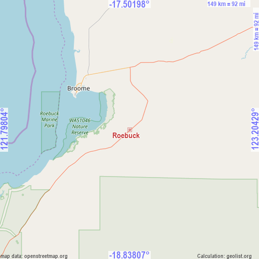
Roebuck GPS coordinates[2]
18° 10' 16.68" South, 122° 30' 4.176" East
| Map corner | latitude | longitude |
|---|---|---|
| Upper-left | -17.50198°, | 121.79804° |
| Center: | -18.1713°, | 122.50116° |
| Lower-right: | -18.83807°, | 123.20429° |
| Map W x H: | 148.6×148.6 km | = 92.3×92.3mi |
| max Lat: | -10.58257° ⇑3.9% North |
| Roebuck: | -18.1713° |
| min Lat: | ⇓96.1% South -43.31423° |
| min Long | Roebuck | max Long |
| 113.53327° | 122.50116° | 153.61246° |
| W 11.2%⇐ | ⇒88.8% E |
Elevation
Elevation of Roebuck is 48 m = 157 ft, and this is 74 m = 243 ft below average elevation for this country.
| Max E: |
1715 m = 5627 ft | 48% |
| Avg. | 122 m = 400 ft | |
| Roebuck | 48 m = 157 ft | |
Min E: |
-2 m = -7 ft | 52% |
See also: Australia elevation on elevation.city.
Geographical zone
Roebuck is located in South Torrid zone (between Equator and Tropic of Capricorn). Distance of this Southern Tropic circle is 585.5 km =363.8 mi to South.| Distance of | km | miles | from Roebuck |
|---|---|---|---|
| Equator | 2020.5 | 1255.5 | to North |
| Tropic Capricorn | 585.5 | 363.8 | to South |
| Antarctic Circle | 5380.7 | 3343.4 | to South |
| South Pole | 7986.6 | 4962.6 | to South |


Nearby cities:
13 places around Roebuck: (largest is in red/bold)
• Bilingurr
40.9 km =25.4 mi,  315°
315°
• Broome
36.6 km =22.7 mi,  310°
310°
• Cable Beach
38.4 km =23.9 mi, 307°
• Camballin
179.6 km =111.6 mi,  83°
83°
• Dampier Peninsula
143.1 km =88.9 mi,  15°
15°
• Derby
153.6 km =95.4 mi,  51°
51°
• Djugun
37.7 km =23.4 mi, 309°
• Eighty Mile Beach
151.3 km =94 mi,  218°
218°
• Fitzroy Crossing
323.8 km =201.2 mi,  90°
90°
• King Leopold Ranges
337 km =209.4 mi,  69°
69°
• Lagrange
94.5 km =58.7 mi,  233°
233°
• St George Ranges
279.2 km =173.5 mi,  108°
108°
• Telfer
347.3 km =215.8 mi,  166°
166°
Sources, notices
• [Note1] Compared only with cities in Australia existing in our database
• [Src1] Map data: © OpenStreetMap contributors (CC-BY-SA)
• [Src2] Other city data from geonames.org with taken over terms of usage.
• [Src3] Geographical zone / Annual Mean Temperature by Robert A. Rohde @ Wikipedia
