Halls Gap geodata
Halls Gap (Victoria) is a populated place; located in Australia in Australia/Melbourne (GMT+11) time zone. With population of 603 people, there are 4557 cities with bigger population in this country. Compared to other cities in Australia, 81.9% of cities are located further ↑North; 74.3% of cities are located further →East and 84.2% of cities have lower elevation than Halls Gap. Note1


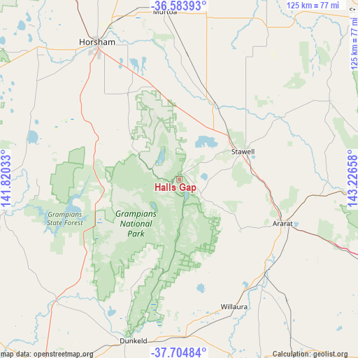
Halls Gap GPS coordinates[2]
37° 8' 47.256" South, 142° 31' 24.42" East
| Map corner | latitude | longitude |
|---|---|---|
| Upper-left | -36.58393°, | 141.82033° |
| Center: | -37.14646°, | 142.52345° |
| Lower-right: | -37.70484°, | 143.22658° |
| Map W x H: | 124.6×124.6 km | = 77.4×77.4mi |
| max Lat: | -10.58257° ⇑81.9% North |
| Halls Gap: | -37.14646° |
| min Lat: | ⇓18.1% South -43.31423° |
| min Long | Halls Gap | max Long |
| 113.53327° | 142.52345° | 153.61246° |
| W 25.7%⇐ | ⇒74.3% E |
Elevation
Elevation of Halls Gap is 234 m = 768 ft, and this is 112 m = 367 ft above average elevation for this country.
| Max E: |
1715 m = 5627 ft | 15.8% |
| Halls Gap | 234 m 768 ft | |
| Avg. | 122 m = 400 ft | |
Min E: |
-2 m = -7 ft | 84.2% |
See also: Australia elevation on elevation.city.
Geographical zone
Halls Gap is located in South temperate zone (between Tropic of Capricorn and the Antarctic Circle). Distance of this Southern Tropic circle is 1524.4 km =947.2 mi to North.| Distance of | km | miles | from Halls Gap |
|---|---|---|---|
| Equator | 4130.3 | 2566.4 | to North |
| Tropic Capricorn | 1524.4 | 947.2 | to North |
| Antarctic Circle | 3270.9 | 2032.4 | to South |
| South Pole | 5876.8 | 3651.7 | to South |


Nearby cities:
15 places around Halls Gap: (largest is in red/bold)
• Ararat
39 km =24.2 mi,  113°
113°
• Avoca
84.5 km =52.5 mi,  85°
85°
• Beaufort
82.4 km =51.2 mi, 112°
• Coleraine
89.1 km =55.4 mi,  235°
235°
• Dimboola
88.3 km =54.9 mi,  330°
330°
• Dunkeld
58.2 km =36.2 mi,  195°
195°
• Hamilton
79.9 km =49.6 mi,  213°
213°
• Haven
51.9 km =32.2 mi, 325°
• Horsham
56.3 km =35 mi, 329°
• Murtoa
58.7 km =36.5 mi,  355°
355°
• Penshurst
83.6 km =51.9 mi,  194°
194°
• Rupanyup
58.4 km =36.3 mi,  9°
9°
• Skipton
95.5 km =59.3 mi,  128°
128°
• Stawell
24.9 km =15.5 mi,  66°
66°
• Willaura
48.3 km =30 mi,  156°
156°
Sources, notices
• [Note1] Compared only with cities in Australia existing in our database
• [Src1] Map data: © OpenStreetMap contributors (CC-BY-SA)
• [Src2] Other city data from geonames.org with taken over terms of usage.
• [Src3] Geographical zone / Annual Mean Temperature by Robert A. Rohde @ Wikipedia
