Stawell geodata
Stawell (Victoria) is a populated place; located in Australia in Australia/Melbourne (GMT+11) time zone. With population of 5,889 people, there are 1231 cities with bigger population in this country. Compared to other cities in Australia, 81.6% of cities are located further ↑North; 74.1% of cities are located further →East and 85.4% of cities have lower elevation than Stawell. Note1


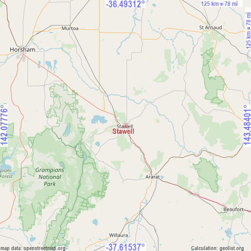
Stawell GPS coordinates[2]
37° 3' 22.752" South, 142° 46' 51.168" East
| Map corner | latitude | longitude |
|---|---|---|
| Upper-left | -36.49312°, | 142.07776° |
| Center: | -37.05632°, | 142.78088° |
| Lower-right: | -37.61537°, | 143.48401° |
| Map W x H: | 124.8×124.8 km | = 77.5×77.5mi |
| max Lat: | -10.58257° ⇑81.6% North |
| Stawell: | -37.05632° |
| min Lat: | ⇓18.4% South -43.31423° |
| min Long | Stawell | max Long |
| 113.53327° | 142.78088° | 153.61246° |
| W 25.9%⇐ | ⇒74.1% E |
Elevation
Elevation of Stawell is 254 m = 833 ft, and this is 132 m = 433 ft above average elevation for this country.
| Max E: |
1715 m = 5627 ft | 14.6% |
| Stawell | 254 m 833 ft | |
| Avg. | 122 m = 400 ft | |
Min E: |
-2 m = -7 ft | 85.4% |
See also: Australia elevation on elevation.city.
Geographical zone
Stawell is located in South temperate zone (between Tropic of Capricorn and the Antarctic Circle). Distance of this Southern Tropic circle is 1514.4 km =941 mi to North.| Distance of | km | miles | from Stawell |
|---|---|---|---|
| Equator | 4120.3 | 2560.2 | to North |
| Tropic Capricorn | 1514.4 | 941 | to North |
| Antarctic Circle | 3280.9 | 2038.7 | to South |
| South Pole | 5886.8 | 3657.9 | to South |


Nearby cities:
15 places around Stawell: (largest is in red/bold)
• Ararat
28.6 km =17.8 mi,  153°
153°
• Avoca
61.6 km =38.3 mi,  93°
93°
• Beaufort
67.6 km =42 mi,  127°
127°
• Carisbrook
91.9 km =57.1 mi, 89°
• Donald
78.5 km =48.8 mi,  13°
13°
• Dunkeld
76.5 km =47.5 mi,  210°
210°
• Dunolly
87.4 km =54.3 mi,  75°
75°
• Halls Gap
24.9 km =15.5 mi,  246°
246°
• Haven
61.6 km =38.3 mi,  302°
302°
• Horsham
64.4 km =40 mi,  306°
306°
• Maryborough
85.1 km =52.9 mi, 89°
• Murtoa
56 km =34.8 mi,  330°
330°
• Rupanyup
49.4 km =30.7 mi,  344°
344°
• Skipton
87 km =54.1 mi,  143°
143°
• Willaura
54.5 km =33.9 mi,  183°
183°
Sources, notices
• [Note1] Compared only with cities in Australia existing in our database
• [Src1] Map data: © OpenStreetMap contributors (CC-BY-SA)
• [Src2] Other city data from geonames.org with taken over terms of usage.
• [Src3] Geographical zone / Annual Mean Temperature by Robert A. Rohde @ Wikipedia
