Ararat geodata
Ararat (Victoria) is a populated place; located in Australia in Australia/Melbourne (GMT+11) time zone. With population of 8,275 people, there are 791 cities with bigger population in this country. Compared to other cities in Australia, 82.1% of cities are located further ↑North; 74% of cities are located further →East and 88.5% of cities have lower elevation than Ararat. Note1


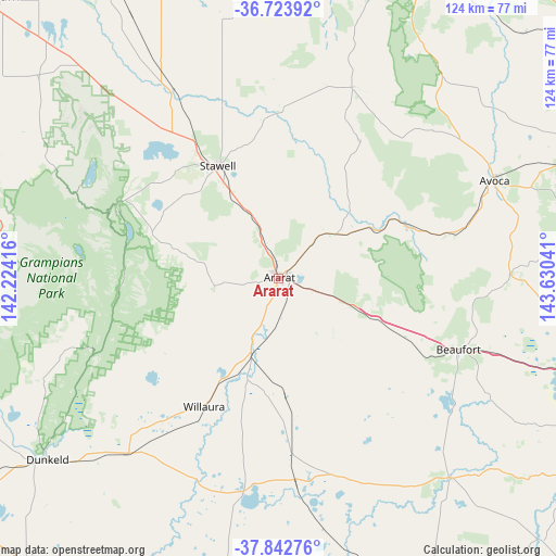
Ararat GPS coordinates[2]
37° 17' 7.512" South, 142° 55' 38.208" East
| Map corner | latitude | longitude |
|---|---|---|
| Upper-left | -36.72392°, | 142.22416° |
| Center: | -37.28542°, | 142.92728° |
| Lower-right: | -37.84276°, | 143.63041° |
| Map W x H: | 124.4×124.4 km | = 77.3×77.3mi |
| max Lat: | -10.58257° ⇑82.1% North |
| Ararat: | -37.28542° |
| min Lat: | ⇓17.9% South -43.31423° |
| min Long | Ararat | max Long |
| 113.53327° | 142.92728° | 153.61246° |
| W 26%⇐ | ⇒74% E |
Elevation
Elevation of Ararat is 325 m = 1066 ft, and this is 203 m = 666 ft above average elevation for this country.
| Max E: |
1715 m = 5627 ft | 11.5% |
| Ararat | 325 m 1066 ft | |
| Avg. | 122 m = 400 ft | |
Min E: |
-2 m = -7 ft | 88.5% |
See also: Australia elevation on elevation.city.
Geographical zone
Ararat is located in South temperate zone (between Tropic of Capricorn and the Antarctic Circle). Distance of this Southern Tropic circle is 1539.8 km =956.8 mi to North.| Distance of | km | miles | from Ararat |
|---|---|---|---|
| Equator | 4145.8 | 2576.1 | to North |
| Tropic Capricorn | 1539.8 | 956.8 | to North |
| Antarctic Circle | 3255.4 | 2022.8 | to South |
| South Pole | 5861.3 | 3642 | to South |


Nearby cities:
15 places around Ararat: (largest is in red/bold)
• Avoca
53 km =32.9 mi,  65°
65°
• Beaufort
43.4 km =27 mi,  111°
111°
• Cardigan
77.7 km =48.3 mi, 110°
• Cardigan Village
74.1 km =46 mi, 110°
• Clunes
76 km =47.2 mi,  90°
90°
• Dunkeld
65.5 km =40.7 mi,  231°
231°
• Halls Gap
39 km =24.2 mi,  293°
293°
• Linton
71.6 km =44.5 mi,  128°
128°
• Maryborough
76.7 km =47.7 mi, 69°
• Rupanyup
77.6 km =48.2 mi,  340°
340°
• Skipton
58.9 km =36.6 mi,  139°
139°
• Smythesdale
77.9 km =48.4 mi,  120°
120°
• Snake Valley
68.5 km =42.6 mi, 121°
• Stawell
28.6 km =17.8 mi,  333°
333°
• Willaura
33.3 km =20.7 mi,  209°
209°
Sources, notices
• [Note1] Compared only with cities in Australia existing in our database
• [Src1] Map data: © OpenStreetMap contributors (CC-BY-SA)
• [Src2] Other city data from geonames.org with taken over terms of usage.
• [Src3] Geographical zone / Annual Mean Temperature by Robert A. Rohde @ Wikipedia
