Ashford geodata
Ashford (New South Wales) is a populated place; located in Australia in Australia/Sydney (GMT+11) time zone. With population of 642 people, there are 4468 cities with bigger population in this country. Compared to other cities in Australia, 73% of cities are located further ↓South; 69.7% of cities are located further ←West and 91.7% of cities have lower elevation than Ashford. Note1


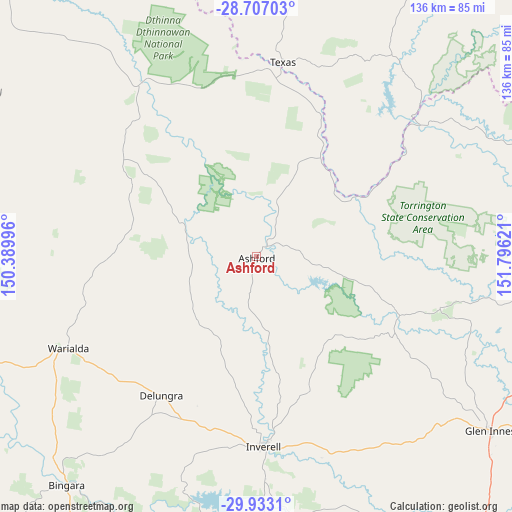
Ashford GPS coordinates[2]
29° 19' 18.876" South, 151° 5' 35.088" East
| Map corner | latitude | longitude |
|---|---|---|
| Upper-left | -28.70703°, | 150.38996° |
| Center: | -29.32191°, | 151.09308° |
| Lower-right: | -29.9331°, | 151.79621° |
| Map W x H: | 136.3×136.3 km | = 84.7×84.7mi |
| max Lat: | -10.58257° ⇑27% North |
| Ashford: | -29.32191° |
| min Lat: | ⇓73% South -43.31423° |
| min Long | Ashford | max Long |
| 113.53327° | 151.09308° | 153.61246° |
| W 69.7%⇐ | ⇒30.3% E |
Elevation
Elevation of Ashford is 433 m = 1421 ft, and this is 311 m = 1020 ft above average elevation for this country.
| Max E: |
1715 m = 5627 ft | 8.3% |
| Ashford | 433 m 1421 ft | |
| Avg. | 122 m = 400 ft | |
Min E: |
-2 m = -7 ft | 91.7% |
See also: Australia elevation on elevation.city.
Geographical zone
Ashford is located in South temperate zone (between Tropic of Capricorn and the Antarctic Circle). Distance of this Southern Tropic circle is 654.4 km =406.6 mi to North.| Distance of | km | miles | from Ashford |
|---|---|---|---|
| Equator | 3260.3 | 2025.9 | to North |
| Tropic Capricorn | 654.4 | 406.6 | to North |
| Antarctic Circle | 4140.9 | 2573 | to South |
| South Pole | 6746.8 | 4192.3 | to South |


Nearby cities:
15 places around Ashford: (largest is in red/bold)
• Bingara
79 km =49.1 mi,  219°
219°
• Boggabilla
107 km =66.5 mi,  318°
318°
• Bundarra
94.5 km =58.7 mi,  180°
180°
• Carrolls Creek
112.8 km =70.1 mi,  60°
60°
• Delungra
44.9 km =27.9 mi,  214°
214°
• Emmaville
50.8 km =31.6 mi,  105°
105°
• Gilgai
59.1 km =36.7 mi, 177°
• Glen Innes
77.5 km =48.2 mi,  126°
126°
• Inglewood
100.7 km =62.6 mi,  359°
359°
• Inverell
50.3 km =31.3 mi, 177°
• Mitchell
106.9 km =66.4 mi, 112°
• Stanthorpe
110.4 km =68.6 mi,  47°
47°
• Tenterfield
94.9 km =59 mi,  71°
71°
• Tingha
71.4 km =44.4 mi,  170°
170°
• Warialda
55.9 km =34.7 mi,  243°
243°
Sources, notices
• [Note1] Compared only with cities in Australia existing in our database
• [Src1] Map data: © OpenStreetMap contributors (CC-BY-SA)
• [Src2] Other city data from geonames.org with taken over terms of usage.
• [Src3] Geographical zone / Annual Mean Temperature by Robert A. Rohde @ Wikipedia
