Inglewood geodata
Inglewood (Queensland) is a populated place; located in Australia in Australia/Brisbane (GMT+10) time zone. With population of 945 people, there are 3905 cities with bigger population in this country. Compared to other cities in Australia, 74.6% of cities are located further ↓South; 69.3% of cities are located further ←West and 86.9% of cities have lower elevation than Inglewood. Note1


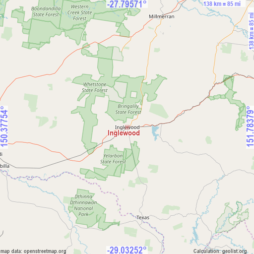
Inglewood GPS coordinates[2]
28° 24' 57.312" South, 151° 4' 50.376" East
| Map corner | latitude | longitude |
|---|---|---|
| Upper-left | -27.79571°, | 150.37754° |
| Center: | -28.41592°, | 151.08066° |
| Lower-right: | -29.03252°, | 151.78379° |
| Map W x H: | 137.5×137.5 km | = 85.4×85.4mi |
| max Lat: | -10.58257° ⇑25.4% North |
| Inglewood: | -28.41592° |
| min Lat: | ⇓74.6% South -43.31423° |
| min Long | Inglewood | max Long |
| 113.53327° | 151.08066° | 153.61246° |
| W 69.3%⇐ | ⇒30.7% E |
Elevation
Elevation of Inglewood is 284 m = 932 ft, and this is 162 m = 531 ft above average elevation for this country.
| Max E: |
1715 m = 5627 ft | 13.1% |
| Inglewood | 284 m 932 ft | |
| Avg. | 122 m = 400 ft | |
Min E: |
-2 m = -7 ft | 86.9% |
See also: Australia elevation on elevation.city.
Geographical zone
Inglewood is located in South temperate zone (between Tropic of Capricorn and the Antarctic Circle). Distance of this Southern Tropic circle is 553.6 km =344 mi to North.| Distance of | km | miles | from Inglewood |
|---|---|---|---|
| Equator | 3159.6 | 1963.3 | to North |
| Tropic Capricorn | 553.6 | 344 | to North |
| Antarctic Circle | 4241.6 | 2635.6 | to South |
| South Pole | 6847.5 | 4254.8 | to South |


Nearby cities:
15 places around Inglewood: (largest is in red/bold)
• Allora
97.8 km =60.8 mi,  64°
64°
• Ashford
100.7 km =62.6 mi,  179°
179°
• Boggabilla
73.5 km =45.7 mi,  253°
253°
• Cambooya
109.2 km =67.9 mi,  44°
44°
• Carrolls Creek
109.6 km =68.1 mi,  114°
114°
• Clifton
97.1 km =60.3 mi, 56°
• Goondiwindi
77.2 km =48 mi,  259°
259°
• Greenmount
106.7 km =66.3 mi,  48°
48°
• Millmerran
62.5 km =38.8 mi,  17°
17°
• Nobby
101.3 km =62.9 mi, 52°
• Pittsworth
94.9 km =59 mi,  34°
34°
• Rosenthal Heights
93.3 km =58 mi,  77°
77°
• Southbrook
102.6 km =63.8 mi, 37°
• Stanthorpe
87.5 km =54.4 mi, 107°
• Warwick
95.9 km =59.6 mi, 76°
Sources, notices
• [Note1] Compared only with cities in Australia existing in our database
• [Src1] Map data: © OpenStreetMap contributors (CC-BY-SA)
• [Src2] Other city data from geonames.org with taken over terms of usage.
• [Src3] Geographical zone / Annual Mean Temperature by Robert A. Rohde @ Wikipedia
