Goondiwindi geodata
Goondiwindi (Queensland) is a populated place; located in Australia in Australia/Brisbane (GMT+10) time zone. With population of 6,577 people, there are 1054 cities with bigger population in this country. Compared to other cities in Australia, 74.5% of cities are located further ↓South; 57.9% of cities are located further ←West and 83.2% of cities have lower elevation than Goondiwindi. Note1


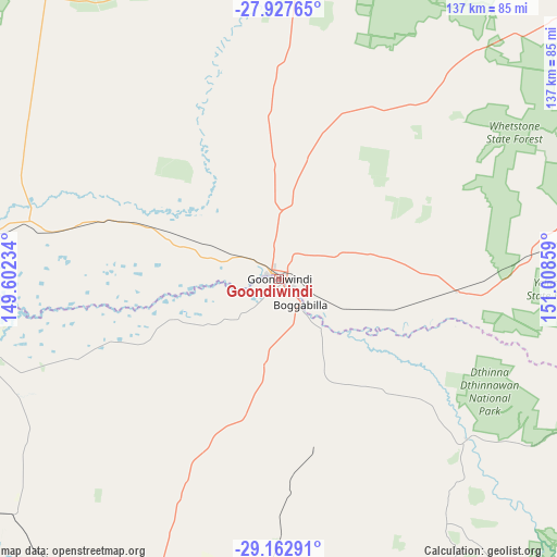
Goondiwindi GPS coordinates[2]
28° 32' 49.524" South, 150° 18' 19.656" East
| Map corner | latitude | longitude |
|---|---|---|
| Upper-left | -27.92765°, | 149.60234° |
| Center: | -28.54709°, | 150.30546° |
| Lower-right: | -29.16291°, | 151.00859° |
| Map W x H: | 137.3×137.3 km | = 85.3×85.3mi |
| max Lat: | -10.58257° ⇑25.5% North |
| Goondiwindi: | -28.54709° |
| min Lat: | ⇓74.5% South -43.31423° |
| min Long | Goondiwindi | max Long |
| 113.53327° | 150.30546° | 153.61246° |
| W 57.9%⇐ | ⇒42.1% E |
Elevation
Elevation of Goondiwindi is 220 m = 722 ft, and this is 98 m = 322 ft above average elevation for this country.
| Max E: |
1715 m = 5627 ft | 16.8% |
| Goondiwindi | 220 m 722 ft | |
| Avg. | 122 m = 400 ft | |
Min E: |
-2 m = -7 ft | 83.2% |
See also: Australia elevation on elevation.city.
Geographical zone
Goondiwindi is located in South temperate zone (between Tropic of Capricorn and the Antarctic Circle). Distance of this Southern Tropic circle is 568.2 km =353.1 mi to North.| Distance of | km | miles | from Goondiwindi |
|---|---|---|---|
| Equator | 3174.1 | 1972.3 | to North |
| Tropic Capricorn | 568.2 | 353.1 | to North |
| Antarctic Circle | 4227 | 2626.5 | to South |
| South Pole | 6832.9 | 4245.8 | to South |


Nearby cities:
15 places around Goondiwindi: (largest is in red/bold)
• Ashford
115.3 km =71.6 mi,  138°
138°
• Bingara
149.3 km =92.8 mi,  170°
170°
• Boggabilla
8.3 km =5.2 mi, 140°
• Delungra
133.2 km =82.8 mi,  157°
157°
• Emmaville
160.4 km =99.7 mi,  128°
128°
• Gilgai
165.2 km =102.7 mi,  151°
151°
• Inglewood
77.2 km =48 mi,  79°
79°
• Inverell
157.3 km =97.7 mi, 150°
• Millmerran
120.2 km =74.7 mi,  51°
51°
• Moree
111.4 km =69.2 mi,  203°
203°
• Mungindi
137 km =85.1 mi,  249°
249°
• Pittsworth
159.7 km =99.2 mi, 54°
• Stanthorpe
159.4 km =99 mi,  94°
94°
• Tara
142.1 km =88.3 mi,  6°
6°
• Warialda
113.9 km =70.8 mi, 166°
Sources, notices
• [Note1] Compared only with cities in Australia existing in our database
• [Src1] Map data: © OpenStreetMap contributors (CC-BY-SA)
• [Src2] Other city data from geonames.org with taken over terms of usage.
• [Src3] Geographical zone / Annual Mean Temperature by Robert A. Rohde @ Wikipedia
