Portland geodata
Portland (Victoria) is a populated place; located in Australia in Australia/Melbourne (GMT+11) time zone. With population of 9,429 people, there are 654 cities with bigger population in this country. Compared to other cities in Australia, 95.1% of cities are located further ↑North; 75.3% of cities are located further →East and 79% of cities have higher elevation than Portland. Note1


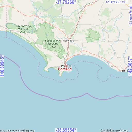
Portland GPS coordinates[2]
38° 20' 46.32" South, 141° 36' 9.252" East
| Map corner | latitude | longitude |
|---|---|---|
| Upper-left | -37.79266°, | 140.89945° |
| Center: | -38.3462°, | 141.60257° |
| Lower-right: | -38.89554°, | 142.3057° |
| Map W x H: | 122.6×122.6 km | = 76.2×76.2mi |
| max Lat: | -10.58257° ⇑95.1% North |
| Portland: | -38.3462° |
| min Lat: | ⇓4.9% South -43.31423° |
| min Long | Portland | max Long |
| 113.53327° | 141.60257° | 153.61246° |
| W 24.7%⇐ | ⇒75.3% E |
Elevation
Elevation of Portland is 16 m = 52 ft, and this is 106 m = 348 ft below average elevation for this country.
| Max E: |
1715 m = 5627 ft | 79% |
| Avg. | 122 m = 400 ft | |
| Portland | 16 m = 52 ft | |
Min E: |
-2 m = -7 ft | 21% |
See also: Australia elevation on elevation.city.
Geographical zone
Portland is located in South temperate zone (between Tropic of Capricorn and the Antarctic Circle). Distance of this Southern Tropic circle is 1657.8 km =1030.1 mi to North.| Distance of | km | miles | from Portland |
|---|---|---|---|
| Equator | 4263.7 | 2649.3 | to North |
| Tropic Capricorn | 1657.8 | 1030.1 | to North |
| Antarctic Circle | 3137.5 | 1949.6 | to South |
| South Pole | 5743.4 | 3568.8 | to South |


Nearby cities:
15 places around Portland: (largest is in red/bold)
• Bolwarra
7.1 km =4.4 mi,  9°
9°
• Bushfield
79.7 km =49.5 mi,  88°
88°
• Casterton
86.4 km =53.7 mi,  348°
348°
• Coleraine
83.5 km =51.9 mi, 5°
• Dennington
72.5 km =45 mi, 90°
• Hamilton
76.3 km =47.4 mi,  28°
28°
• Heywood
23.8 km =14.8 mi, 5°
• Koroit
67 km =41.6 mi,  84°
84°
• Macarthur
49.2 km =30.6 mi,  45°
45°
• Penshurst
79.8 km =49.6 mi, 48°
• Port Fairy
55.5 km =34.5 mi, 94°
• Port MacDonnell
85.4 km =53.1 mi,  292°
292°
• Portland North
5 km =3.1 mi,  326°
326°
• Portland West
2.6 km =1.6 mi,  250°
250°
• Warrnambool
77.3 km =48 mi, 92°
Sources, notices
• [Note1] Compared only with cities in Australia existing in our database
• [Src1] Map data: © OpenStreetMap contributors (CC-BY-SA)
• [Src2] Other city data from geonames.org with taken over terms of usage.
• [Src3] Geographical zone / Annual Mean Temperature by Robert A. Rohde @ Wikipedia
