Collarenebri geodata
Collarenebri (New South Wales) is a populated place; located in Australia in Australia/Sydney (GMT+11) time zone. With population of 669 people, there are 4384 cities with bigger population in this country. Compared to other cities in Australia, 72.7% of cities are located further ↓South; 51.8% of cities are located further ←West and 76.6% of cities have lower elevation than Collarenebri. Note1


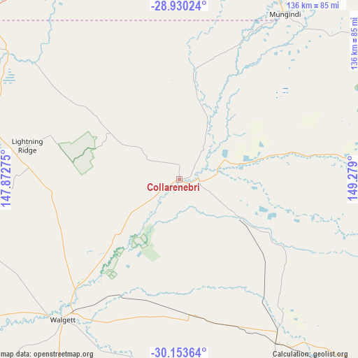
Collarenebri GPS coordinates[2]
29° 32' 37.644" South, 148° 34' 33.132" East
| Map corner | latitude | longitude |
|---|---|---|
| Upper-left | -28.93024°, | 147.87275° |
| Center: | -29.54379°, | 148.57587° |
| Lower-right: | -30.15364°, | 149.279° |
| Map W x H: | 136×136 km | = 84.5×84.5mi |
| max Lat: | -10.58257° ⇑27.3% North |
| Collarenebri: | -29.54379° |
| min Lat: | ⇓72.7% South -43.31423° |
| min Long | Collarenebri | max Long |
| 113.53327° | 148.57587° | 153.61246° |
| W 51.8%⇐ | ⇒48.2% E |
Elevation
Elevation of Collarenebri is 144 m = 472 ft, and this is 22 m = 72 ft above average elevation for this country.
| Max E: |
1715 m = 5627 ft | 23.4% |
| Collarenebri | 144 m 472 ft | |
| Avg. | 122 m = 400 ft | |
Min E: |
-2 m = -7 ft | 76.6% |
See also: Australia elevation on elevation.city.
Geographical zone
Collarenebri is located in South temperate zone (between Tropic of Capricorn and the Antarctic Circle). Distance of this Southern Tropic circle is 679 km =421.9 mi to North.| Distance of | km | miles | from Collarenebri |
|---|---|---|---|
| Equator | 3285 | 2041.2 | to North |
| Tropic Capricorn | 679 | 421.9 | to North |
| Antarctic Circle | 4116.2 | 2557.7 | to South |
| South Pole | 6722.1 | 4176.9 | to South |


Nearby cities:
15 places around Collarenebri: (largest is in red/bold)
• Baradine
163.2 km =101.4 mi,  163°
163°
• Bingara
196.1 km =121.9 mi,  100°
100°
• Blair Athol
198.8 km =123.5 mi,  128°
128°
• Boggabri
191.5 km =119 mi, 132°
• Brewarrina
172 km =106.9 mi,  254°
254°
• Coonamble
157.8 km =98.1 mi,  186°
186°
• Dirranbandi
111.9 km =69.5 mi,  342°
342°
• Lightning Ridge
59.2 km =36.8 mi,  282°
282°
• Moree
122.8 km =76.3 mi,  85°
85°
• Mungindi
74.7 km =46.4 mi,  32°
32°
• Narrabri
145.1 km =90.2 mi, 126°
• St George
177.5 km =110.3 mi,  1°
1°
• Walgett
69.5 km =43.2 mi,  219°
219°
• Warialda
193.4 km =120.2 mi, 89°
• Wee Waa
112.7 km =70 mi, 132°
Sources, notices
• [Note1] Compared only with cities in Australia existing in our database
• [Src1] Map data: © OpenStreetMap contributors (CC-BY-SA)
• [Src2] Other city data from geonames.org with taken over terms of usage.
• [Src3] Geographical zone / Annual Mean Temperature by Robert A. Rohde @ Wikipedia
